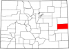
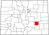
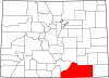
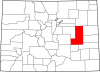
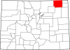
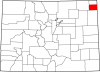
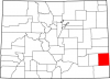
Baca County
Full Article
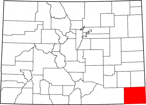
Baca County
Located in Colorado's southeastern corner, Baca County covers 2,557 square miles. An agricultural county, Baca County was hit hard during the Dust Bowl (1934-40).
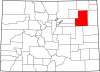
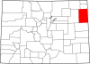
Baca County is a rural, agricultural county on the southern plains encompassing an area of 2,557 square miles in the southeast corner of Colorado. It borders Bent and Prowers Counties to the north, Las Animas County to the west, the state of Kansas to the east, and the states of New Mexico and Oklahoma to the south. Historically, the area of Baca County has been controlled by four different governments: Spain, Mexico, Texas, and the United States, and it has also been home to several Native American groups, primarily the Plains Apache and Comanche. Today, Baca County supports a population of more than 3,788 and is unevenly quartered by two main highways: US Route 160 runs east-west through the county and intersects with the north-southbound US Route 287.
Ancient Inhabitants
Based on evidence from stone tools, projectile points, petroglyphs, pictographs (rock paintings), and other artifacts found in the Baca County area, archaeologists believe it was inhabited as early as 2500 BC. Little is known about the area’s earliest inhabitants, but some of the rock art has given archaeologists a vague idea of their religion, migration patterns, and other aspects of their culture. Over time, weathering, vandalism, and the hands of visitors have degraded the ancient rock art and complicated efforts to interpret it.
Comanche Conquest
The Spanish Crown claimed the area of Baca County in 1541. Multiple Spanish expeditions came through the area over the ensuing century, but it remained part of the northern extreme of Spain’s New World Empire and was not permanently occupied by its subjects. By the 1720s, using horses obtained from the Spanish, the Comanche had driven the sedentary Plains Apache from the region. At this time, the area of Baca County was in the heart of an expanding Comanche territory that ran north and south between the Arkansas and Cimarron Rivers and stretched from the Sangre de Cristo Mountains in the west to what is today south-central Kansas in the east.
Following the Treaty of Paris in 1763, the area of Baca County remained a Spanish possession on paper and a Comanche possession in reality. The area became part of Mexico after it won independence from Spain in 1821. In 1836 the area changed flags again; this time it was part of a Mexican concession to the Republic of Texas. The Baca County area remained part of Texas after it was admitted to the Union in 1845 but was reorganized into the Kansas Territory in 1854. Throughout this time, conflict between the Comanches and non-natives persisted, as neither the Mexicans nor the Texans could fully dislodge the mounted warriors from their homeland. The United States continued fighting the Comanche on the southern plains after 1854.
County Formation
The Baca County area became part of the Colorado Territory in 1861. The first legislature included it as part of Huerfano County, which at the time covered most of the territory’s southeastern reaches. The period between the mid-1840s and the mid-1860s was marked by a severe drought in the Comanche heartland, which killed or forced out hundreds of bison. Also, to maintain the complex trading network that allowed them to survive and prosper on the southern plains, the Comanches had to keep killing bison at an unsustainable rate. Incessant streams of white settlers into Colorado, Kansas, and Texas expanded grazing lands and depleted cottonwood groves along the rivers; both actions exacerbated the Comanches’ resource dilemma. In the mid-1860s, the crippling drought ended, but so did the American Civil War, which allowed the United States to tighten its grip on the plains. By the mid-1870s, the Comanches’ 150-year dominance of the southern plains had ended.
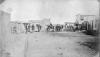
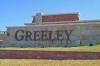
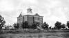
The Comanches’ resource woes in the mid-nineteenth century opened the door for white settlement of the Baca County area. By the 1880s, a number of ranches were established, and in 1887 the town of Springfield was founded. It was named for Springfield, Missouri, the hometown of most of its residents. In 1889 state legislator Casimiro Barela introduced the bill that created Baca County, named for Don Felipe Baca, a prominent businessman from Trinidad. Springfield was named the county seat the same year. As in other plains counties established at the time, ranching and agriculture quickly became the twin centerpieces of the county economy.
Dust Bowl
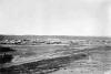
Baca County was the hardest-hit county in Colorado during the Dust Bowl (1934–40). In the 1920s, the arrival of the Santa Fe Railroad led to the establishment of the towns of Walsh, Pritchett, and Bartlett. As the county’s population expanded and agricultural demand swelled, farmers used newly developed farm machines to rip up huge chunks of the county’s native grasses and replaced them with irrigated fields of wheat and corn. When the first of several severe droughts hit the Great Plains in 1934, there were no grass roots to keep the topsoil down, and the incessant wind whipped it up into enormous dark clouds. The wind piled the dust in great drifts, some of which partially or completely covered homes, fences, and cars. Many families were forced to abandon their farms. Deposits at the Springfield Bank fell 77 percent between 1931 and 1936. Wheat was not harvested again in Baca County until 1940, and by then the population had dropped from 10,570 in 1930 to 6,207.
The Dust Bowl and the Great Depression that accompanied it prompted Congress to take action to preserve the ecology and economic viability of the Great Plains. In 1935, Public Law 46 made soil and water conservation a national policy. The federal government also bought 440,000 acres of cultivated land in southeastern Colorado and returned it to native grassland. In 1960, this land was designated as the Comanche National Grassland. It is managed by the US Forest Service, which maintains an office in Springfield.
American Agricultural Movement
In 1977, small farmers in Baca County and elsewhere on the Great Plains were struggling under the weight of debt, low prices for farm products, and federal agricultural policies that favored large-scale producers. When the 1977 Farm Bill continued to incentivize large-scale production and did not implement price supports, 140 angry farmers in southeastern Colorado met in the tiny town of Campo on September 6 to discuss their options.
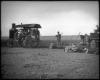
They outlined plans for a national farm strike, during which no farmer would sell any products until the government revised the previous two farm bills to include appropriate price supports. The group called itself the American Agricultural Strike (AAS) and planned to bring several hundred more farmers together in Springfield the following week to announce the strike. To rally more farmers to the cause, AAS members posted flyers and called friends, neighbors, and media outlets. At the Springfield meeting, more than 700 farmers from Colorado, Kansas, New Mexico, Oklahoma, and Texas agreed to initiate a nationwide farm strike beginning on December 14. A national headquarters for the strike was set up in Springfield, and the group was renamed the American Agricultural Movement (AAM). Members immediately began publicizing the strike, and three months after the Springfield meeting the AAM had around 1,100 local offices and represented farmers from forty states.
The AAM’s largest rally was held on January 18, 1978, in Washington, DC. Nearly 3,000 farmers, many of whom rode into town on their tractors, demanded that Congress reconsider the farm bill. They garnered legislative support from several members of Congress, were invited to congressional hearings, and succeeded in influencing the passage of the Emergency Assistance Act of 1978. The act increased farm price supports by 11 percent, but AAM members remained disappointed, as it seemed they had had enough congressional support to pass a more robust bill. Worse, many farmers did not have the resources to sustain the strike, and it ended at the beginning of the 1978 planting season with virtually no impact on American agricultural production.
In 1979 a second AAM rally was held in Washington, but a year of rising tension in the farm community – largely the result of the failure of the first rally – made the participants belligerent. Farmers damaged property and blocked traffic with their tractors and refused to cooperate with authorities. Congress would not hear them this time. After the 1979 strike, the AAM continued to organize, inform, and defend the interests of farmers nationwide, but it would never again be as large or as influential as it was in the winter of 1978.
Today
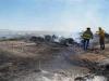
Baca County and the rest of southeast Colorado is in the midst of a severe drought that began in 2010. The region has not seen average amounts of precipitation since 2007, when it was hit by several blizzards. In some areas, annual rainfall has dropped from 12–16 inches to fewer than 8 inches. In April 2014, a round of dust storms nearly as bad as those that ravaged the county in the 1930s robbed farmers of huge amounts of precious topsoil. The increasing intensity of the current drought has prompted many farmers to leave Baca County for wetter and more productive areas of the state and the country.