Bent County
Full Article
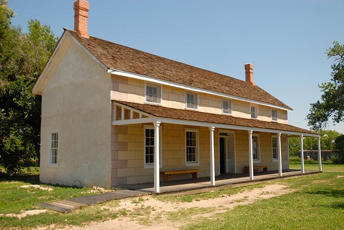
Restored Home of Thomas Boggs
In 1866, former trader Thomas O. Boggs founded the agricultural community of Boggsville, the first such community in Bent County and one of the earliest in the state. Unoccupied since 1975, the Boggs’ family house, shown here, has been restored as part of the Boggsville Historic Site.
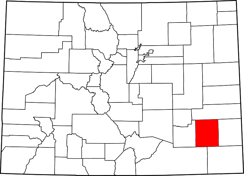
Bent County
Bent County, named for the famous nineteenth-century trader William Bent, lies along the Arkansas River in southeast Colorado.
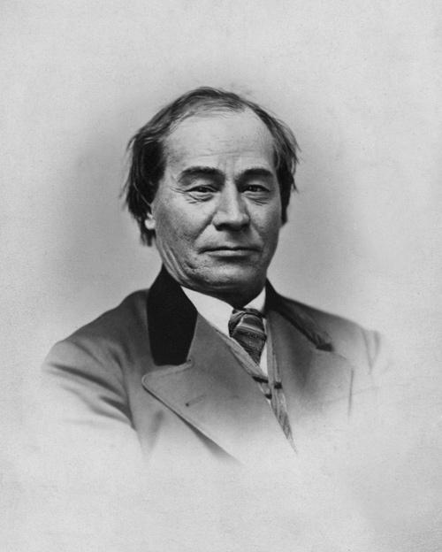
William Bent
William Bent (1809-69) built an adobe trading post on the Arkansas River west of present-day Las Animas in 1833. Bent's Fort was situated along the Santa Fé Trail that connected Missouri and Mexico and quickly became the center of trade on the Great Plains.
Bent County is a rural, agricultural county in southeastern Colorado covering 1,541 square miles of the Great Plains and the fertile Arkansas River valley. It is bordered by Kiowa County to the north, Prowers County to the east, Otero County to the west, and Las Animas and Baca Counties to the south. Nearly a third of Bent County’s 6,500 residents live in the county seat of Las Animas, located at the junction of the Arkansas and Purgatoire Rivers. The county is named for William Bent, the prominent nineteenth-century trader who established Bent’s Fort, a trading post on the Arkansas River just a few miles west of present-day Las Animas.
Comanche Conquest
Beginning in 1540, after Spanish expeditions declared the surrounding lands useless, the Bent County area remained part of the northern extreme of Spain’s New World Empire and was not permanently occupied by its subjects. By the 1720s, the Comanche had used horses obtained from the Spanish to drive the sedentary Plains Apache from the Arkansas River Valley. At this time, the area of Bent County was in the heart of an expanding Comanche territory that ran north and south between the Arkansas and Cimarron Rivers and stretched from the Sangre de Cristo Mountains in the west to what is today south-central Kansas in the east. Of particular value to the Comanches was a section of the Arkansas River Valley they called “Big Timbers,” a veritable plains oasis. This grove of cottonwood trees stretched east of the Purgatoire River for about sixty miles and provided the Comanches and their horses with food and shelter during the harsh plains winters.
In the mid-eighteenth century, the Comanches were the dominant group in the Bent County area, but they depended on warfare and trade with others to survive. They constantly raided and fought with Spanish New Mexicans to the south and occasionally clashed with the Arapaho, who roamed the plains to the north of the Arkansas River Valley. In the 1740s, the Comanches formed an alliance with the Taovaya Wichita on the eastern edge of their territory. In exchange for captured Apaches, robes, and horses, the sedentary Taovaya provided the Comanche with maize, beans, and squash, as well as weapons and tools procured from French traders in Louisiana. Sometimes the Frenchmen themselves came to trade; by 1748 as many as thirty-three French traders had visited the Comanches, coming away with deerskins, captured Indigenous slaves, horses, and other animals.
Cheyenne
Adding to the complexity of the Indigenous-European trade network along the Arkansas River were the Cheyenne, who arrived in the early 1820s after the Lakota forced them out of their original homeland in the Black Hills. The Cheyenne replaced the Kiowa and Naishan as middlemen for the Comanche horse trade, sending the animals to native groups in the Missouri Valley to the northeast. But in the late 1820s, Lakota raids decimated those groups, and diseases ravaged the Cheyenne and Arapaho. Out of necessity, both groups broke off their alliance with the Comanche and invaded the Arkansas basin, seeking among other gains the precious shelter of the Big Timbers.
In the 1820s, the establishment of the Santa Fé Trail, cutting across the Comanche heartland, attracted white American traders to the Bent County region. In 1830, following the advice of a young Cheyenne leader, the American traders Ceran St. Vrain and William and Charles Bent relocated their trading post to a large adobe fort on the Arkansas River, just east of present-day La Junta. In its new location, Bent’s Fort became the trading center of the plains and a threat to the Comanches; the Cheyennes were the Bents’ primary trading partners, and through trade at the fort they obtained weapons to fight the Comanches.
Both sides suffered heavy casualties in the ensuing war until peace was made in 1839. Over the next year, the Arapahos, Cheyennes, Comanches, Kiowas, and Naishans formed an unprecedented alliance of Plains Indigenous groups. Importantly, all groups retained the right to winter in the Big Timbers. The peace also allowed the Comanches to begin trading directly with Bent’s Fort.
Decline of Trade
For the next several years, the Bent County area was the center of a lucrative regional trade, but it did not last. The Comanches had to kill large numbers of bison to keep up their massive raid-and-trade empire. By the late 1840s, overhunting and a period of extreme drought combined to decimate the bison population. The sudden shortage of bison scattered the previously allied groups of Plains Indians in different directions, searching for better sources of food and supplies. White pioneers also began using the Arkansas River Valley as a westward corridor at this time; their wagon trains trampled grazing grass and consumed precious timber supplies as fuel wood. As if the Native Americans’ situation had not deteriorated enough, a cholera epidemic in 1849 ravaged every native group on the Colorado plains.
The epidemic was the final blow to the regional trade centered at Bent’s Fort but not to the fort itself. Distraught over its failure, William Bent stocked powder barrels against the fort’s adobe walls and blew it up. He built another trading post further downriver in 1853, but the escalating tensions between whites and Native Americans ensured that his trade business would never recover. He leased the new fort to the US Army, which renamed it Fort Lyon in 1862. Bent continued to trade with Indians, even serving as Indian agent for the upper Arkansas tribes in 1859, but the warfare following the Sand Creek Massacre in 1864 finally isolated him from the people with whom he had spent most of his life. Bent died of pneumonia on his Las Animas ranch in 1869.
County Establishment
The decline of trade at Bent’s Fort had former traders searching for new careers. One ex-trader, Thomas O. Boggs, founded the town of Boggsville just west of the Purgatoire River in 1866. In 1867, Boggs’s friend Kit Carson, the former mountain man, Indian agent, and soldier, settled in Boggsville to begin a ranching career; Carson died a year later at Fort Lyon. In 1868, William Bent’s son Robert, along with Boggs and John Wesley Prowers, set up the first irrigation project in Bent County, which put 1,000 acres of corn, wheat, and potatoes into cultivation. Boggsville was also the site of Bent County’s first school, founded in 1869 by Miss Mattie Smith.
By the mid-1870s, a combination of resource woes and immense pressure from the American military brought an end to Comanche dominance of the Bent County area. Colorado Territory’s eighth legislative assembly officially created the county in 1870, a year after the death of its namesake, William Bent. Boggsville was designated the county seat, but in the early 1870s the town was bypassed by railroads and abandoned by its founding families. The county seat was moved to Las Animas in 1875.
The Kansas-Pacific and other railroads built lines through the county, turning Las Animas into the final destination for livestock from southern Colorado and northern New Mexico. Bent County itself was home to many cattle ranches, while the fertile land around the Arkansas River Valley was converted to farms. In 1884, construction began on the Fort Lyon Canal, one of the largest irrigation projects in Colorado history. When completed, the canal supplied water to nearly 100,000 acres of farmland in Bent and Otero Counties.
Fort Lyon
In 1907, the US Navy assumed ownership of Fort Lyon and converted it into a treatment center for tuberculosis patients. After 1922, the Veterans Administration (VA) owned the fort and turned it into a hospital for veterans suffering from neuro-psychiatric conditions. The VA operated it until 2001, when the state of Colorado purchased the site from the federal government for one dollar and converted it into a state prison designed to house inmates with serious psychiatric needs.
However, a 2007 investigation by Westword found that of the nearly 500 inmates held there, fewer than 100 actually had special medical needs. Moreover, the facility was found to be exposing inmates and staff to a range of hazardous materials, including asbestos and lead paint. The prison was closed in 2011. Two years later, with support from Governor John Hickenlooper, it reopened as a residential community for the homeless. True to its military and medical roots, the new community places particular emphasis on helping homeless Colorado veterans recover from addiction, mental illness, and other health problems related to homelessness.
Agriculture and Disasters
Agriculture and cattle ranching, the two founding industries of Bent County, continued to drive the local economy in the twentieth century. Major crops included alfalfa, corn, wheat, sugar beets, cantaloupes, onions, barley, oats, and potatoes. After the disastrous Arkansas River flood in 1921, the city of Las Animas built levees that contained floods in 1936, 1955, 1957, and 1965. In 1978, Las Animas built a nine-mile earthen levee designed to protect the city from future floods.
Like elsewhere in southeastern Colorado, ranching and agriculture in Bent County were vulnerable to drought. The Dust Bowl of the 1930s may have hit hardest in Baca County to the south, but Bent County endured its share of farm foreclosures and economic hardship during that time. A second string of droughts hit southeastern Colorado during the mid-1980s and prompted the state government to make Bent County, along with Baca, Crowley, Kiowa, Otero, and Prowers Counties, part of its first Enterprise Zone—an economically depressed area where low income taxes are offered to attract businesses and encourage economic growth.
Today
Today, Bent County maintains a healthy ranching industry and a high level of agricultural production; it holds 676,505 acres of rangeland and more than 115,000 acres of irrigated and non-irrigated cropland.