You are here

Counties

Adams County

Added by yongli on 12/28/2015 - 13:42, last changed on 01/26/2023 - 18:43

Rocky Mountain Arsenal

Share article to
Adams County, named after former Colorado Governor Alva Adams , encompasses 1,184 square miles in northeast Colorado. A long, irregular rectangle, the county stretches across the plains from its western boundary north of Denver to its eastern edge at the intersection of US Route 36 and Meridian...

Alamosa County

Added by yongli on 06/24/2016 - 16:36, last changed on 11/02/2022 - 08:47
Alamosa County, named for the Spanish word for “ cottonwood grove,” is located in the high San Luis Valley of south central Colorado. At 7,544 feet, the valley is bordered by the Sangre de Cristo Mountains on the east and the San Juan Mountains to the west. Alamosa County encompasses 723 square...

Arapahoe County

Added by yongli on 12/28/2015 - 15:28, last changed on 12/22/2022 - 11:42
Arapahoe County covers 805 square miles in north central Colorado, running east across the high plains from the southern edge of Denver . It is named for the Arapaho , who once inhabited the area. One of the oldest counties in the state, Arapahoe County is bordered on the north by Denver and Adams...

Archuleta County

Added by yongli on 06/27/2016 - 13:00, last changed on 11/02/2022 - 05:48
Archuleta County covers 1,356 square miles of the San Juan Mountains in southwestern Colorado. The county is bordered to the north by Hinsdale , Mineral , and Rio Grande Counties; to the west by La Plata County ; to the east by Conejos County ; and to the south by the state of New Mexico. Before...

Baca County

Added by yongli on 04/17/2015 - 13:42, last changed on 11/20/2022 - 22:15
Baca County is a rural, agricultural county on the southern plains encompassing an area of 2,557 square miles in the southeast corner of Colorado. It borders Bent and Prowers Counties to the north, Las Animas County to the west, the state of Kansas to the east, and the states of New Mexico and...

Bent County

Added by yongli on 04/17/2015 - 13:04, last changed on 11/27/2022 - 08:59
Bent County is a rural, agricultural county in southeastern Colorado covering 1,541 square miles of the Great Plains and the fertile Arkansas River valley. It is bordered by Kiowa County to the north, Prowers County to the east, Otero County to the west, and Las Animas and Baca Counties to the...

Boulder County

Added by yongli on 12/28/2015 - 15:47, last changed on 03/01/2023 - 10:41
Boulder County encompasses 740 square miles of the western plains and Rocky Mountains in north central Colorado. The county straddles three unique geographic zones: mountains in the west, plains in the east, and a natural trough that runs between the plains and foothills. Its western boundary,...

Chaffee County

Added by yongli on 01/30/2017 - 16:45, last changed on 11/29/2022 - 14:44
Chaffee County lies in central Colorado on the eastern slope of the Rocky Mountains and along the Upper Arkansas River valley. It is bordered by Lake and Park Counties to the north, Park and Fremont Counties to the east, Saguache County to the south, and Gunnison County to the west. Chaffee County’...

Cheyenne County

Added by yongli on 06/27/2016 - 13:37, last changed on 11/27/2022 - 09:13
Cheyenne County is a sparsely populated county on Colorado’s eastern plains, covering 1,781 square miles. It is named for the Cheyenne, one of many nomadic Native American groups that lived and hunted bison in the area throughout the nineteenth century. Cheyenne County is bordered to the north by...

City and County of Broomfield

Added by yongli on 10/03/2016 - 14:28, last changed on 10/18/2022 - 07:48
The City and County of Broomfield encompasses about thirty-three square miles on the Front Range in central Colorado, mainly between US Highway 36 and Interstate 25 southeast of Boulder . Broomfield supports a population of 65,065 and borders Boulder County to the northwest, Weld County to the...

Clear Creek County

Added by yongli on 01/30/2017 - 11:05, last changed on 11/02/2022 - 12:43
Clear Creek County lies thirty miles west of Denver on the eastern slope of the Rocky Mountains . One of Colorado’s seventeen original counties, it covers 396 square miles and spans Clear Creek Canyon , from which it takes its name. Clear Creek County has a population of 9,303 and is bordered by...

Colorado Congressional Districts

Added by yongli on 06/09/2020 - 14:59, last changed on 11/02/2022 - 08:47
Colorado is divided into seven Congressional districts according to population, with each district represented by an elected member of the United States House of Representatives. Colorado representatives serve two-year terms, as required by the US Constitution. There are no term limits for members...

Conejos County

Added by yongli on 11/04/2016 - 15:55, last changed on 03/08/2023 - 01:40
Conejos County covers 1,287 square miles of the southern San Luis Valley and eastern San Juan Mountains in south central Colorado. It is bordered by Archuleta County to the west, Rio Grande and Alamosa Counties to the north, Costilla County to the east, and New Mexico’s Taos and Rio Arriba Counties...

Costilla County

Added by yongli on 06/27/2016 - 14:45, last changed on 03/17/2023 - 01:41
Costilla County lies in south-central Colorado within the San Luis Valley . It covers nearly 1,227 square miles and ranges in elevation from 8,400 to 10,300 feet. Costilla County borders Conejos County to the west, Alamosa County to the northwest, Huerfano County to the northeast, Las Animas County...

Crowley County

Added by yongli on 11/04/2016 - 16:15, last changed on 11/20/2022 - 22:24
Formed in 1911, Crowley County covers 800 square miles on Colorado’s southeastern Great Plains near the Arkansas River . It is bordered to the north by Lincoln County , to the east by Kiowa County , to the south by Otero County , and to the west by Pueblo County . A heavily agricultural county,...

Custer County

Added by yongli on 03/31/2017 - 16:42, last changed on 11/02/2022 - 12:43
Custer County covers nearly 739 square miles in south central Colorado, spanning the Wet Mountain Valley between the Sangre de Cristo Mountains in the west and the Wet Mountains in the east. It is bordered by Fremont County to the north, Pueblo County to the east, Huerfano County to the south, and...

Delta County

Added by yongli on 03/04/2016 - 10:21, last changed on 12/20/2022 - 11:41
Delta County covers 1,149 square miles of the Gunnison and Uncompahgre River valleys in west central Colorado, including the southern part of Grand Mesa and the northern part of the Uncompahgre Plateau. The county is bordered to the north and west by Mesa County , to the east by Gunnison County ,...

Dolores County

Added by yongli on 08/16/2016 - 10:50, last changed on 11/15/2022 - 10:43

Rico

Share article to
Dolores County is a sparsely populated county in southwestern Colorado, named for the river that flows from the San Juan Mountains on its eastern flank. It covers 1,068 square miles and is bordered to the north by San Miguel County , to the east by San Juan County , to the southeast by La Plata...

Douglas County

Added by yongli on 02/21/2017 - 16:36, last changed on 02/02/2023 - 18:40
Douglas County covers 843 square miles between Denver and Colorado Springs on the western Great Plains along the Front Range . The county was established in 1861 as one of the original seventeen counties of the Colorado Territory . It is bordered to the north by Arapahoe County , to the east by...

Eagle County

Added by yongli on 10/06/2016 - 14:47, last changed on 11/02/2022 - 05:48
Eagle County, formed in 1883, covers 1,692 square miles of mountainous terrain in northwest Colorado. It is named for the Eagle River , which begins in the mountains in the county’s southeast corner, flows westward alongside Interstate 70 , and meets the Colorado River near the small community of...

El Paso County

Added by yongli on 06/22/2016 - 14:45, last changed on 11/01/2022 - 18:44
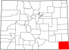
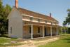
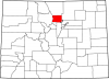
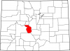
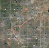
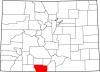
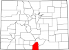
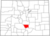
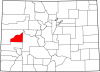
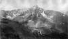
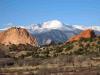
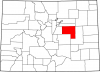
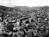
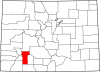
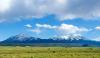
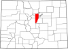
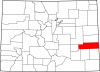
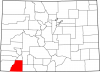
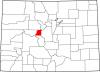
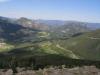
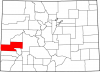
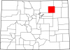
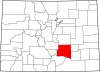
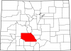
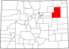
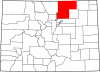
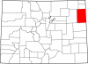
El Paso County covers 2,130 square miles in east central Colorado, situated between the southern end of the Front Range and the Great Plains . Pikes Peak , the state’s most famous mountain, lies within its borders, and the county seat, Colorado Springs , is the second-largest city in Colorado. El...

Elbert County

Added by yongli on 04/27/2017 - 16:44, last changed on 11/20/2022 - 22:23
Elbert County, named for former Colorado territorial governor Samuel H. Elbert , covers 1,851 square miles on the Great Plains southeast of Denver . It is bordered to the north by Arapahoe County , to the east and south by Lincoln County , to the south by El Paso County , and to the west by Douglas...

Fremont County

Added by yongli on 01/31/2017 - 10:47, last changed on 01/26/2023 - 09:34
Fremont County is located in south-central Colorado, bordered by Park and Teller Counties to the north, El Paso County to the east, Pueblo County to the southeast, Custer County to the south, and Saguache and Chaffee Counties to the north. Fremont County comprises 1,533 square miles with an...

Garfield County

Added by yongli on 12/28/2015 - 16:01, last changed on 11/15/2022 - 09:43
Named for former president James Garfield, Garfield County is a mountainous county in western Colorado. Covering 2,956 square miles, it is bordered to the north by Rio Blanco County , to the east by Routt and Eagle Counties, to the south by Pitkin and Mesa Counties, and to the west by the state of...

Gilpin County

Added by yongli on 11/14/2016 - 10:51, last changed on 11/17/2022 - 00:37
Gilpin County, located in the high country east of the Continental Divide some thirty-seven miles west of Denver , was established in 1861 as one of the original seventeen counties of the Colorado Territory . The county encompasses about 150 square miles of mountainous terrain that ranges in...

Grand County

Added by yongli on 11/14/2016 - 12:52, last changed on 11/02/2022 - 06:40
Established in 1874, Grand County lies in the north central Rocky Mountains some sixty-seven miles west of Denver . It is named for the Grand River, an early name for the Colorado River . Encompassing 1,868 square miles, Grand County is bordered to the north by Jackson County , to the northeast by...

Gunnison County

Added by yongli on 02/23/2016 - 16:22, last changed on 11/08/2022 - 18:43
Gunnison County, named for the American explorer John W. Gunnison , is a large, mountainous county in west-central Colorado. A sparsely populated county of 3,260 square miles, it includes some 1.5 million acres of national forest and wilderness lands, including the Gunnison National Forest ,...

Hinsdale County

Added by yongli on 11/14/2016 - 13:05, last changed on 11/08/2022 - 21:42
Established in 1874, Hinsdale County is a mountainous, sparsely populated county of 1,123 square miles in southwest Colorado. The county was named for George A. Hinsdale , a prominent politician and newspaperman in nineteenth-century Colorado. The county currently has a population of 786. Lake City...

Huerfano County

Added by yongli on 01/31/2017 - 12:36, last changed on 03/15/2023 - 07:39
Huerfano County, named for the Spanish word for “orphan,” covers 1,750 square miles in south central Colorado, east of the Sangre de Cristo Mountains and south of the Wet Mountain Valley . The southern part of Huerfano County is part of the Raton Basin, a geological formation that has produced...

Jackson County

Added by yongli on 11/14/2016 - 13:35, last changed on 11/20/2022 - 22:27
Jackson County, named after former US President Andrew Jackson, covers 1,621 square miles in northern Colorado. It encompasses North Park , a large intermountain basin that holds the headwaters of the North Platte River . The North Platte flows north out of Jackson County into Wyoming. The county’s...

Jefferson County

Added by yongli on 03/31/2017 - 16:35, last changed on 11/09/2022 - 12:41
Jefferson County, commonly referred to as “Jeffco,” is named after former president Thomas Jefferson and covers 774 square miles in central Colorado west of Denver. Jeffco is bordered to the north by Boulder and Broomfield Counties, to the east by Adams , Denver , Arapahoe , and Douglas Counties,...

Kiowa County

Added by yongli on 11/14/2016 - 13:40, last changed on 11/02/2022 - 06:40
Kiowa County, named for the Kiowa people who once lived in the area, covers 1,786 square miles of the Great Plains in eastern Colorado. The county is bordered by Cheyenne County to the north, the state of Kansas to the east, Prowers and Bent Counties to the south, and Crowley and Lincoln Counties...

Kit Carson County

Added by yongli on 11/14/2016 - 16:10, last changed on 11/02/2022 - 16:38
Kit Carson County, named for fur trapper and Army scout Kit Carson , covers 2,162 miles of the Great Plains in eastern Colorado. One of the state’s most productive agricultural counties, Kit Carson is bordered to the north by Yuma and Washington Counties, to the east by the state of Kansas, to the...

La Plata County

Added by yongli on 08/16/2016 - 10:31, last changed on 11/29/2022 - 14:44
La Plata County covers 1,700 square miles in southwest Colorado. It is named for the La Plata River and La Plata Mountains, both of which are named for the Spanish word for “silver.” La Plata County is bordered to the north by San Juan County , to the east by Hinsdale and Archuleta counties, to the...

Lake County

Added by yongli on 10/29/2015 - 14:20, last changed on 11/02/2022 - 13:54
One of Colorado’s original seventeen counties, Lake County is a mountainous, 384-square mile county in the west-central part of the state. Leadville , a historic mining town ringed by tall peaks near the headwaters of the Arkansas River , serves as county seat; at 10,152 feet, it is the highest...

Larimer County

Added by yongli on 03/01/2016 - 09:30, last changed on 11/02/2022 - 06:40
Located in north central Colorado, Larimer County encompasses more than 2,600 square miles of plains , foothills, and high mountains in the northern Front Range . The county shares its northern border with Wyoming and borders Weld County to the east, Jackson and Grand Counties to the west, and...

Las Animas County

Added by yongli on 11/14/2016 - 16:20, last changed on 03/16/2023 - 07:41
Las Animas County, the largest county in Colorado, covers 4,775 square miles in the southern end of the state, east of the Sangre de Cristo Mountains . It was originally part of a larger Huerfano County that encompassed all of southeast Colorado. Today, it is bordered by Huerfano County to the...

Lincoln County

Added by yongli on 09/29/2016 - 15:29, last changed on 11/02/2022 - 16:38
Lincoln County, named after President Abraham Lincoln, covers 2,586 square miles of Colorado’s Great Plains southeast of Denver. It is bordered to the north by Washington County , to the east by Kit Carson and Cheyenne Counties, to the southeast by Kiowa County , to the south by Crowley County ,...

Logan County

Added by yongli on 09/29/2016 - 15:57, last changed on 11/12/2022 - 10:04
Logan County, named for Civil War General John A. Logan, covers 1,845 miles of the Great Plains in northeast Colorado. It is bordered to the north by the state of Nebraska, to the east by Sedgwick and Phillips Counties, to the southeast by Yuma County , to the south by Washington County , to the...

Mesa County

Added by yongli on 06/27/2016 - 15:11, last changed on 11/17/2022 - 01:41
Mesa County is situated on 3,341 square miles of the eastern Colorado Plateau in western Colorado. The county is named for the wide, flat-topped mountains within its borders. The Spanish called such mountains mesas —meaning “tables.” The county’s largest mesa, Grand Mesa , rises more than 11,000...

Mineral County

Added by yongli on 10/05/2016 - 16:45, last changed on 11/02/2022 - 05:48
Mineral County is a mountainous, sparsely populated county of 878 square miles in southwest Colorado. Located in the heart of the San Juan Mountains west of the San Luis Valley , the county takes its name from the rich mineral deposits found there in the nineteenth century. In 1892 miners...

Moffat County

Added by yongli on 02/24/2016 - 15:54, last changed on 12/28/2022 - 17:41
Moffat County, named for Denver mining and railroad mogul David Moffat , covers 4,751 square miles of Colorado’s northwest corner. It sits on the northern edge of the Colorado Plateau and is bordered by the state of Wyoming to the north, Routt County to the east, Rio Blanco County to the south, and...

Montezuma County

Added by yongli on 06/27/2016 - 15:03, last changed on 11/02/2022 - 05:48
Montezuma County, famous for the ancient Native American ruins at Mesa Verde , is the southwesternmost county in Colorado. The county covers 2,040 square miles of the Colorado Plateau , and has the distinction of bordering Utah, New Mexico, and Arizona. It is known as the Four Corners region, where...

Montrose County

Added by yongli on 11/14/2016 - 16:29, last changed on 11/09/2022 - 15:42
Montrose County covers 2,243 square miles in western Colorado. Named for its seat, Montrose , the county is bordered to the north by Mesa and Delta Counties, to the east by Gunnison County , to the south by Ouray and San Miguel Counties, and to the west by the state of Utah. The county...

Morgan County

Added by yongli on 09/29/2016 - 16:20, last changed on 11/02/2022 - 12:54
Morgan County covers 1,294 square miles of the South Platte valley and the Great Plains northeast of Denver. It is bordered by Weld County to the north and west, Logan and Washington Counties to the north and east, and Adams and Washington Counties to the south. The county has a...

Otero County

Added by yongli on 10/29/2015 - 14:30, last changed on 03/09/2023 - 15:42
Otero County is located in southeastern Colorado and covers 1,270 square miles of rolling plains and the fertile Arkansas River valley. It is bordered by Pueblo County to the west, Crowley and Kiowa Counties to the north, Bent County to the east, and Las Animas County to the south and southwest...

Ouray County

Added by yongli on 02/24/2016 - 16:00, last changed on 11/26/2022 - 21:39
Ouray County, named after nineteenth-century Ute leader Ouray , is a small county of 524 square miles in southwestern Colorado. It is bisected by the Uncompahgre River , which flows from Lake Como northeast of Silverton , through the county seat of Ouray , through Ridgway and Colona, and out of the...

Park County

Added by yongli on 01/30/2017 - 11:27, last changed on 12/27/2022 - 17:38
Park County covers 2,211 square miles of the Rocky Mountains in central Colorado. Park County’s elevation rages from 7,000 to 14,000 feet. The county’s namesake and dominant geographic feature is South Park, a large, high-altitude basin containing the headwaters of the South Platte River . Park...

Phillips County

Added by yongli on 09/30/2016 - 11:11, last changed on 11/02/2022 - 16:38
Phillips County covers 688 square miles on the Great Plains of northeastern Colorado. It has a population of 4,349, more than half of whom live in the county seat of Holyoke . Other communities include Haxton (pop. 946) and Amherst (58). Frenchman Creek is the only source of surface water for the...

Pitkin County

Added by yongli on 02/24/2016 - 16:58, last changed on 02/15/2023 - 00:38
Pitkin County, named after former Colorado governor Frederick Pitkin , is located in west-central Colorado, spanning 973 square miles of mountains and the Roaring Fork River valley. It is bordered by Garfield and Eagle Counties to the north, Lake and Chaffee Counties to the east, Gunnison County to...

Prowers County

Added by yongli on 11/15/2016 - 08:57, last changed on 11/02/2022 - 16:38
Prowers County covers 1,644 square miles of the Great Plains and Arkansas River valley in southeastern Colorado. The rectangular county is bordered to the north by Kiowa County , to the east by the state of Kansas, to the south by Baca County , and to the west by Bent County . Prowers County has a...

Pueblo County

Added by yongli on 11/15/2016 - 10:03, last changed on 11/30/2022 - 18:41
Pueblo County covers 2,398 square miles in southeast Colorado, from the southern Front Range and Wet Mountains in the west to the Arkansas River valley and Great Plains in the east. It is bordered by El Paso County to the north, Crowley and Otero Counties to the east, Las Animas and Huerfano...

Rio Blanco County

Added by yongli on 03/31/2017 - 16:39, last changed on 11/02/2022 - 05:48
Rio Blanco County is a remote, mountainous county in northwestern Colorado covering 3,223 square miles. Named for the White River —“Rio Blanco” in Spanish—the county lies on the northern edge of the Colorado Plateau and is bordered to the north by Moffat County , to the east by Routt County , to...

Rio Grande County

Added by yongli on 01/23/2017 - 13:24, last changed on 03/15/2023 - 09:39
Rio Grande County is located in the western San Luis Valley in south-central Colorado. It covers 912 square miles and ranges in elevation from 7,000 feet on the valley floor to over 13,000 feet atop several mountain peaks. Del Norte is the county seat, and Monte Vista , operating as a Home-Rule...

Routt County

Added by yongli on 02/02/2017 - 16:26, last changed on 12/04/2022 - 23:39
Routt County is a large county in northwest Colorado, encompassing 2,368 square miles of the Elk and Yampa River valleys and the Park Range and Elkhead Mountains. It is bordered by the state of Wyoming to the north, Jackson and Grand Counties to the east, Eagle County to the south, and Rio Blanco...

Saguache County

Added by yongli on 01/23/2017 - 14:08, last changed on 11/02/2022 - 06:40
Known as the northern gateway to the San Luis Valley , Saguache County covers 3,168 miles between the Sangre de Cristo and San Juan Mountain ranges in southern Colorado. The word Saguache , pronounced “Sa-watch,” is derived from the Ute language and means “blue-green Earth”—a reference to the...

San Juan County

Added by yongli on 06/27/2016 - 15:27, last changed on 11/02/2022 - 12:43
San Juan County was established just before Colorado became a state in 1876. It initially stretched from the Utah border in the west to its present border in the east. The next year, the first state assembly allocated most of San Juan County’s western portion to the newly formed Ouray County, and...

San Miguel County

Added by yongli on 08/16/2016 - 10:45, last changed on 11/15/2022 - 15:40
San Miguel County covers 1,289 square miles in southwest Colorado. Named for the river that flows northwest across its eastern flank, the county is bordered to the north by Montrose County , to the east by Ouray County , to the southeast by San Juan County , to the south by Dolores County , and to...

Sedgwick County

Added by yongli on 01/31/2017 - 10:24, last changed on 11/02/2022 - 12:54
Sedgwick County covers 549 square miles in the northeastern corner of Colorado. It was established in 1889 and named for Fort Sedgwick . Straddling the South Platte River , the county is bordered by Nebraska’s Deuel and Perkins Counties to the north and east, and by Colorado’s Phillips and Logan...

Summit County

Added by Nick Johnson on 12/11/2015 - 07:56, last changed on 11/10/2022 - 01:42
Summit County is a mountainous county in central Colorado, approximately sixty-five miles west of Denver . Originally one of the largest of Colorado’s first seventeen counties, Summit County’s current border connects a ring of peaks around an area of 619 square miles. It is bordered to the north by...

Teller County

Added by yongli on 08/16/2016 - 10:40, last changed on 01/31/2023 - 22:41
Teller County, named for former US senator and railroad mogul Henry M. Teller , covers 559 square miles of the high country west of Pikes Peak in central Colorado. It is bordered by Douglas County to the north, El Paso County to the east, Fremont County to the south, and Park County to the west...

Washington County

Added by yongli on 09/30/2016 - 11:23, last changed on 11/02/2022 - 16:38
Washington County, named for the first US president, is a county of 2,524 square miles on Colorado’s eastern Great Plains . It is bordered to the north by Logan County , to the east by Yuma County , to the south by Kit Carson and Lincoln Counties, and to the west by Arapahoe , Adams , and Morgan...

Weld County

Added by yongli on 12/29/2015 - 10:51, last changed on 11/27/2022 - 09:12
Weld County is the largest county in northeastern Colorado, covering 4,017 square miles of the Great Plains and the South Platte River valley. One of the original seventeen counties in the Colorado Territory , it is named for Louis Ledyard Weld, the first territorial secretary. The county is...

Yuma County

Added by yongli on 09/30/2016 - 12:30, last changed on 11/02/2022 - 16:38
Yuma County covers 2,369 square miles in northeast Colorado. A part of the state’s Great Plains region, the county includes the lowest point in Colorado: 3,315 feet, along the Arikaree River at the Kansas border. Yuma County is bordered to the east by Cheyenne County, Kansas, to the south by Kit...
Subscribe to Counties