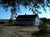
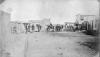
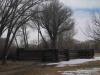
Named for its location seventeen miles from the intersection of Broadway and Colfax Avenue in Denver, Seventeen Mile House operated in the 1860s and 1870s as a tavern and inn along the southern branch of the Smoky Hill Trail. After the arrival of the…
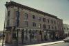
The most prominent building at the Five Points intersection in Denver, the Rossonian Hotel opened in 1912 as the Baxter Hotel. Renamed the Rossonian in 1929, its lounge acquired a reputation as the best jazz club between the Midwest and the West Coast,…
Morgan County’s 1921 jail and 1936 courthouse in Fort Morgan replaced the county’s original facilities after the county had outgrown them. The courthouse was funded by the Public Works Administration (PWA) and designed by the modernist Colorado architect…
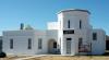
Located about seven miles north of Woodland Park, the Manitou Experimental Forest Station was established in 1936 for the US Forest Service to study resource management in ponderosa pine lands. Along with the Fraser Experimental Forest, it is one of two…
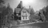
Originally built in the early 1870s at the mouth of Queens Canyon in Colorado Springs, Glen Eyrie was home to city founder William Jackson Palmer. In the early twentieth century Palmer expanded the house into an elaborate stone castle, but he died soon…
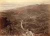
El Corazon de Trinidad (“the heart of Trinidad”) National Historic District covers a particularly well-preserved portion of downtown Trinidad that includes many blocks of adobe and brick buildings from the late nineteenth and early twentieth centuries…
Built in 1894, the Cheyenne County Jail represented the young county’s dedication to law and order and helped instill a sense of civic pride. It is the only surviving jail designed by the important early Colorado architect Robert S. Roeschlaub. After a…
Indian Agencies were established by the US government as part of the formal relationship with Indigenous nations as it acquired lands from them. Indian Agents were individuals responsible for cultivating relationships with Indigenous people and extending…
The Overland Trail, also known as the "Central Overland Emigrant Route," was an important nineteenth-century corridor for explorers, colonists, miners, and traders that ran from Atchison, Kansas, to Fort Bridger, Wyoming. It followed preexisting…
On February 19, 2015, President Obama designated 21,586 acres of scenic canyons, rivers, and backcountry forest in Chaffee County, Colorado, as the Browns Canyon National Monument. Browns Canyon is the eighth national monument designation within the…
The Pike Stockade is a reconstruction of a small fortress built by the soldiers of the 1806–7 Zebulon Pike expedition. It is located on the Rio Conejos, a tributary of the Rio Grande, in the San Luis Valley, seventeen miles southeast of Alamosa…
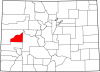
Delta County covers 1,149 square miles of the Gunnison and Uncompahgre River valleys in west central Colorado, including the southern part of Grand Mesa and the northern part of the Uncompahgre Plateau. The county is bordered to the north and west by…
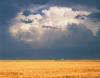
Eastern Colorado, bordered by the foothills of the Rocky Mountains on the west, Kansas on the east, and the corners of Nebraska and Oklahoma, constitutes a portion of the Great Plains. It is the agricultural heartland of Colorado. This semiarid region is…
The Denver Mountain Park system consists of forty-six public parks that are home to some of the most popular mountain destinations near Denver, including Red Rocks, William “Buffalo Bill” Cody’s Grave, Evergreen Lake, Lookout Mountain, and Echo Lake…
Located in north central Colorado, Larimer County encompasses more than 2,600 square miles of plains, foothills, and high mountains in the northern Front Range. The county shares its northern border with Wyoming and borders Weld County to the east,…
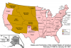
The Territory of Colorado (1861–76) was the predecessor to the state of Colorado, created on February 28, 1861. The territory was formed in response to the secession crisis as well as a massive influx of white immigrants during the…
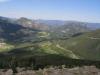
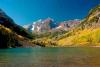
Pitkin County, named after former Colorado governor Frederick Pitkin, is located in west-central Colorado, spanning 973 square miles of mountains and the Roaring Fork River valley. It is bordered by Garfield and Eagle Counties to the north, Lake and…
Ouray County, named after nineteenth-century Ute leader Ouray, is a small county of 524 square miles in southwestern Colorado. It is bisected by the Uncompahgre River, which flows from Lake Como northeast of Silverton, through the county seat of Ouray,…
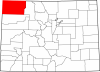
Moffat County, named for Denver mining and railroad mogul David Moffat, covers 4,751 square miles of Colorado’s northwest corner. It sits on the northern edge of the Colorado Plateau and is bordered by the state of Wyoming to the north, Routt County to…
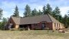
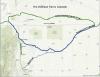
The Bee Family Farm is a historic farm located between Fort Collins and Wellington. In operation as a working farm since 1894, it is now an outdoor museum that preserves and displays the family’s historic artifacts, buildings, and fields to help visitors…