Denver, Northwestern & Pacific Railway Hill Route (Moffat Road)
Full Article
Construction on the Denver, Northwestern & Pacific Railway Hill Route, also known as the Moffat Road, began in 1904 and was completed in the late 1920s. The route connected the Front Range to Middle Park via Rollins Pass. Built in part on a former Ute trail and intended as a temporary route across the Continental Divide, the arduous twenty-three-mile section of railroad served for twenty-four years before the Moffat Tunnel was completed in 1928. Since the railroad ties were taken out in the 1930s, the old railroad bed has been popular with four-wheel-drive enthusiasts and other outdoor adventurers.
Before the Railroad
Long before any wagons or railroad cars crossed the Continental Divide, the Ute people realized that what is now Rollins Pass, at an elevation of 11,660 feet, was a good place to traverse the mountains. They established a trail over the pass from South Boulder Creek to Middle Park and must have used it many times. The first documented crossings of the divide at Rollins Pass occurred in the 1860s. In August 1862, a company of American soldiers under Captain John Bonesteel crossed the pass to get to Hot Sulphur Springs. In 1865 William Byers, a group of California Volunteers, and a wagon train of Mormons all traveled over the pass.
Meanwhile a local businessman, John Quincy Adams Rollins, had established the town of Rollinsville and acquired mining and ranching properties in the area. He thought it would be good for business to have a wagon road through Rollinsville that would connect Denver and other Front Range cities to Middle Park.
In 1866 the Colorado Territorial legislature incorporated the Middle Park and South Boulder Wagon Road Company and granted Rollins, Perley Dodge, and Frederic C. Weir the right to operate a wagon road along the old Ute trail over the mountains. Known as the Rollinsville and Middle Park Wagon Road, the thirty-mile road opened in 1873 with a $2.50 toll. The road opened Middle Park for tourism and quickly increased trade between Middle Park and the Front Range. The route was difficult to maintain, however, and soon lost traffic to a rival road that Georgetown merchants built over the Continental Divide at Berthoud Pass.
Building the Moffat Road
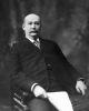
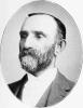
At the start of the twentieth century, the prominent Denver businessman David Moffat became determined to build a transcontinental railroad west from Denver to Salt Lake City and ultimately to the Pacific. The transcontinental railroads built in the late nineteenth century had all bypassed Denver in favor of easier routes across the mountains to the north or south. To go west from Denver would require building an expensive tunnel through the mountains or traversing the Continental Divide at a high elevation. In the 1880s, the Denver, Utah & Pacific Railroad had started to build a tunnel under the divide near Rollins Pass, but the project ground to a halt before much work could be completed. Twenty years later, Moffat believed such a route would justify itself financially by opening up valuable coal, lumber, and livestock resources in northwestern Colorado.
To realize his transcontinental dream, Moffat incorporated the Denver, Northwestern & Pacific Railroad in July 1902. He hired Horace Sumner as the railroad’s locating engineer and established the Colorado-Utah Construction Company to build the railroad, which would go from Denver to the foothills via Leyden Mesa, then turn north and follow South Boulder Creek to the Continental Divide. The original plan called for a tunnel under the Continental Divide around Rollins Pass or James Peak to reach Middle Park. It was estimated that a tunnel under the mountains would take at least two or three years to build, however, so in the meantime the railroad decided to build a temporary route that would cross the divide at Rollins Pass.
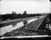
Eventually known as the Moffat Road (or the Hill Route), the route followed the old wagon road from South Boulder Creek to Jenny Creek. It then took a longer but gentler route the rest of the way to the pass. Major landmarks along the way included Yankee Doodle Lake, which the railroad looped around to make a 180 degree turn; Needle’s Eye Tunnel; and the Devil’s Slide Twin Trestles high above the South Fork of Middle Boulder Creek. On the western side of the divide, the railroad descended via a series of switchbacks (even looping under itself at one point) to get down to the Berthoud Pass wagon road on the valley floor.
Construction along the twenty-three-mile route proceeded quickly. Rails reached Rollinsville in May 1904 and made it to Boulder Park, about four miles west, by June. That summer Denver tourists began to take the train for excursions to Mammoth, where they could escape the heat at an elevation of nearly 8,900 feet. On September 2, 1904, tracks reached the summit of Rollins Pass, and by the end of the month the railroad had made it down the west side of the divide to Arrowhead (later Arrow) at 9,585 feet. From there construction continued through Middle Park, reaching Hot Sulphur Springs in August 1905.
“Temporary” Route
Although meant to be temporary, the Moffat Road operated for twenty-four years, from 1904 to 1928. In 1904 the railroad thought a tunnel would take three years and $4 million, but the project’s cost and estimated construction time continued to climb. Moffat had trouble raising money for the tunnel, in part because Edward H. Harriman of the Union Pacific Railroad did everything he could to stop construction on a potential rival to his own transcontinental route. When Moffat died in 1911, his railroad had not yet reached Craig. It soon foundered, reorganized as the Denver & Salt Lake Railroad, and was ultimately acquired by the Denver & Rio Grande Western Railroad.
One reason for the railroad’s financial struggles was that it quickly became clear that the Moffat Road would be difficult to operate. Already in the winter of 1904–5, just a few months after the route was completed to Arrowhead, heavy snows prevented daily service. Despite long snow sheds and heavy-duty snowplows, the route continued to face extended closures, sometimes for several weeks at a time, whenever winter storms pounded the Continental Divide. By the 1920s snow clearance on the Moffat Road accounted for 41 percent of the route’s operating expenses.
Even in good weather, the trip over Rollins Pass proved arduous. After climbing at a 2 percent grade up South Boulder Creek from the foothills, the route shifted to a 4 percent grade as it turned away from the creek and climbed the sweeping switchbacks known as the Giant’s Ladder. Trains slowed to a crawl as they gained 2,500 vertical feet from South Boulder Creek to Rollins Pass and then rolled down 2,000 feet to Arrow, a journey that took at least two and a half hours in perfect conditions.
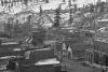
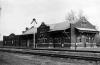
Nevertheless, the Moffat Road developed into a popular summer excursion from Denver. Trains regularly carried hundreds of visitors from Denver to Tolland (formerly Mammoth), where they enjoyed an eating house and a dance hall. Named for the Toll family, which owned land in the area and operated the popular Toll Inn, the weekend getaway soon grew to include other businesses and summer cabins.
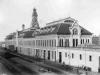
The railroad station at Rollins Pass, known as Corona (“crown”), made for an even cooler summer destination. It was the highest standard-gauge railroad station in the United States. Down in sweltering Denver, the railroad advertised the station, which featured a hotel and restaurant, as the “top of the world” and “Colorado’s north pole.” Postcards pictured tourists making snowballs in July.
After the Moffat Tunnel
In 1922 the Colorado legislature passed a bill to fund construction of the long-planned Moffat Tunnel under the Continental Divide. The 6.2-mile tunnel started operation in 1928 and immediately made the steep and snowy twenty-three-mile Moffat Road obsolete, cutting the time for that section of the railroad to just twelve minutes.
In 1935 the old tracks and ties were removed from the Moffat Road, which began to be used for recreation. Over the next two decades the route became popular among four-wheel-drive enthusiasts and other outdoor adventurers, but it was not very well maintained until 1956, when Boulder, Gilpin, and Grand Counties joined with the Colorado Division of Wildlife (now Colorado Parks and Wildlife) to improve the old railroad grade for use by passenger vehicles. At that time the counties also signed maintenance agreements with the US Forest Service.
In recent decades, however, the Moffat Road has suffered significant natural damage. A 1979 rockfall at Needle’s Eye Tunnel closed the road there until 1988. Another rockfall two years later closed that portion of the road again, and the tunnel remains unstable until further repairs are made. The Devil’s Slide Twin Trestles have also been closed to vehicular traffic since 1982. A portion of the Rollinsville and Middle Park Wagon Road has been reopened so that four-wheel-drive vehicles can continue to use the route to access Rollins Pass.
In 1980 the Moffat Road was listed on the National Register of Historic Places. In 2012 Colorado Preservation named the route an “Endangered Place” because it had few interpretive materials, received little maintenance, and was gradually deteriorating as extreme weather took its toll.
10th Grade
The Denver, Northwestern & Pacific Railway Hill Route, also known as the Moffat Road, was completed in 1904. It connected the Front Range to Middle Park via Rollins Pass. It was intended as a temporary route across the Continental Divide. The difficult twenty-three-mile section of railroad served for twenty-four years before the Moffat Tunnel was completed in 1928. Since the railroad ties were taken out in the 1930s, the old railroad bed has been popular with four-wheel-drive enthusiasts and other outdoor adventurers.
Before the Railroad
Hundreds of years ago, Ute Indians realized that what is now Rollins Pass was a good place to cross the mountains. They established a trail over the pass from South Boulder Creek to Middle Park and used it many times. The first documented crossings of the divide at Rollins Pass occurred in the 1860s. In August 1862, a company of American soldiers under Captain John Bonesteel crossed the pass to get to Hot Sulphur Springs.
Meanwhile a local businessman, John Quincy Adams Rollins, had established the town of Rollinsville. He bought mining and ranching properties in the area. He thought it would be good for business to have a wagon road through Rollinsville that would connect Denver and other Front Range cities to Middle Park.
In 1866 the Colorado Territorial legislature incorporated the Middle Park and South Boulder Wagon Road Company and granted Rollins, Perley Dodge, and Frederic C. Weir the right to operate a wagon road. The thirty-mile road opened in 1873 with a $2.50 toll. The road opened Middle Park for tourism and quickly increased trade between Middle Park and the Front Range. The route was difficult to maintain. It soon lost traffic to a rival road that Georgetown merchants built over the Continental Divide at Berthoud Pass.
Building the Moffat Road
At the start of the twentieth century, the prominent Denver businessman David Moffat became determined to build a transcontinental railroad west from Denver to Salt Lake City. The transcontinental railroads built in the late nineteenth century had all bypassed Denver. To go west from Denver would require building an expensive tunnel through the mountains or crossing the Continental Divide. In the 1880s, the Denver, Utah & Pacific Railroad had started to build a tunnel under the divide near Rollins Pass. The project halted before much work could be completed. Twenty years later, Moffat believed such a route would justify itself financially by opening up valuable coal, lumber, and livestock resources in northwestern Colorado.
To realize his transcontinental dream, Moffat incorporated the Denver, Northwestern & Pacific Railroad in July 1902. The original plan called for a tunnel under the Continental Divide around Rollins Pass or James Peak to reach Middle Park. It was estimated that a tunnel under the mountains would take at least two or three years to build. In the meantime, the railroad decided to build a temporary route that would cross the divide at Rollins Pass. It was eventually known as the Moffat Road.
“Temporary” Route
Although meant to be temporary, the Moffat Road operated for twenty-four years, from 1904 to 1928. When Moffat died in 1911, his railroad had not yet reached Craig. Soon afterwards, it failed and was reorganized as the Denver & Salt Lake Railroad. Ultimately, it was acquired by the Denver & Rio Grande Western Railroad.
One reason for the railroad’s financial struggles was that it quickly became clear that the Moffat Road would be expensive to operate. The route faced extended closures, sometimes for several weeks at a time, whenever winter storms pounded the Continental Divide. By the 1920s, snow clearance on the Moffat Road accounted for 41 percent of the route’s operating expenses.
Even in good weather, the trip over Rollins Pass proved difficult. The journey from Boulder Creek to Arrow took at least two and a half hours in perfect conditions.
Nevertheless, the Moffat Road developed into a popular summer excursion from Denver. Trains regularly carried hundreds of visitors from Denver to Tolland (formerly Mammoth), where they enjoyed a restaurant and a dance hall.
The railroad station at Rollins Pass, known as Corona (“crown”), made for an even cooler summer destination. It was the highest standard-gauge railroad station in the United States. Down in sweltering Denver, the railroad advertised the station, which featured a hotel and restaurant, as the “top of the world” and “Colorado’s north pole.” Postcards pictured tourists making snowballs in July.
After the Moffat Tunnel
In 1922 the Colorado legislature passed a bill to fund construction of the long-planned Moffat Tunnel under the Continental Divide. The 6.2-mile tunnel started operation in 1928 and immediately made the steep and snowy Moffat Road obsolete.
In 1935 the old tracks and ties were removed from the Moffat Road, which began to be used for recreation. Over the next two decades the route became popular among four-wheel-drive enthusiasts and other outdoor adventurers, but it was not very well-maintained until 1956, when Boulder, Gilpin, and Grand Counties joined with the Colorado Division of Wildlife (now Colorado Parks and Wildlife) to improve the old railroad grade for use by passenger vehicles. At that time the counties also signed maintenance agreements with the US Forest Service.
In 1980 the Moffat Road was listed on the National Register of Historic Places. In 2012 Colorado Preservation named the route an “Endangered Place” because it had few interpretive materials, received little maintenance, and was gradually deteriorating as extreme weather took its toll.
8th Grade
The Denver, Northwestern & Pacific Railway Hill Route was also known as the Moffat Road. Completed in 1904, it connected the Front Range to Middle Park via Rollins Pass. It was intended as a temporary route across the Continental Divide. This difficult section of railroad served for twenty-four years before the Moffat Tunnel was completed in 1928.
Before the Railroad
Ute Indians used what is now Rollins Pass to cross the mountains into Middle Park. They formed a trail over the pass from South Boulder Creek and used it many times. The first documented crossings of the divide at Rollins Pass occurred in the 1860s. In August 1862, a company of American soldiers under Captain John Bonesteel crossed the pass to get to Hot Sulphur Springs.
A local businessman, John Quincy Adams Rollins, had established the town of Rollinsville. He bought mining and ranching properties in the area. He thought it would be good for business to have a wagon road through Rollinsville that would connect Denver and other Front Range cities to Middle Park.
In 1866 the Colorado Territorial legislature merged the Middle Park and South Boulder Wagon Road Company and gave Rollins and his partners the right to operate a wagon road. The road opened in 1873. Tourism and trade quickly increased between Middle Park and the Front Range. But the route was difficult to maintain. It soon lost traffic to a rival road that Georgetown merchants built over the Continental Divide at Berthoud Pass.
Building the Moffat Road
At the start of the twentieth century, prominent Denver businessman David Moffat became determined to build a transcontinental railroad from Denver through Salt Lake City. To go west from Denver would require building an expensive tunnel through the mountains or crossing the Continental Divide. In the 1880s, the Denver, Utah & Pacific Railroad had started to build a tunnel under the divide near Rollins Pass. The project halted before much work could be completed. Twenty years later, Moffat believed such a route would justify itself financially by opening up valuable coal, lumber, and livestock resources in northwestern Colorado.
To realize his transcontinental dream, Moffat incorporated the Denver, Northwestern & Pacific Railroad in July 1902. The original plan called for a tunnel under the Continental Divide. It was estimated that a tunnel under the mountains would take at least two or three years to build. In the meantime, the railroad would build a temporary route across the divide at Rollins Pass. It was eventually known as the Moffat Road.
“Temporary” Route
Although meant to be temporary, the Moffat Road operated for twenty-four years, from 1904 to 1928. When Moffat died in 1911, his railroad had not yet reached Craig, in northwest Colorado. Soon afterwards, the railroad failed and was reorganized as the Denver & Salt Lake Railroad. Ultimately, it was acquired by the Denver & Rio Grande Western Railroad.
One reason for the railroad’s financial struggles was that the Moffat Road would be expensive to operate. The route faced extended closures, sometimes for several weeks at a time, whenever winter storms pounded the Continental Divide. By the 1920s, snow clearance on the Moffat Road accounted for 41 percent of the route’s operating expenses.
Even in good weather, the trip over Rollins Pass proved difficult. The journey from Boulder Creek to Arrow took at least two and a half hours in perfect conditions.
Nevertheless, the Moffat Road developed into a popular summer trip from Denver. Trains carried visitors from Denver to Tolland (formerly Mammoth), where they enjoyed an eating house and a dance hall.
The railroad station at Rollins Pass, known as Corona (“crown”), was an even cooler summer destination. It was the highest standard-gauge railroad station in the United States. The railroad advertised the station as the “top of the world” and “Colorado’s north pole.” It had a hotel and restaurant.
After the Moffat Tunnel
In 1922 the state legislature funded construction of the Moffat Tunnel under the Continental Divide. The 6.2-mile tunnel started operation in 1928 and made the steep and snowy twenty-three-mile Moffat Road obsolete.
In 1935 the old tracks and ties were removed from the Moffat Road. It began to be used for recreation. It was poorly maintained until 1956, when Boulder, Gilpin, and Grand Counties joined with the Colorado Division of Wildlife (now Colorado Parks and Wildlife) to improve the old railroad grade for use by passenger vehicles. At that time the counties also signed maintenance agreements with the US Forest Service.
In 1980 the Moffat Road was listed on the National Register of Historic Places. In 2012 Colorado Preservation named the route an “Endangered Place” because it was gradually declining as extreme weather took its toll.
4th Grade
The Denver, Northwestern & Pacific Railway Hill Route was a railroad route over Rollins Pass in western Boulder County. It was built by David Moffat, a businessman from Denver. The route is also called the “Moffat Road.”
Long before wagons or railroad cars crossed the Continental Divide, Ute Indians used a trail that is now called Rollins Pass. It travels from South Boulder Creek to Middle Park. The first recorded crossing over Rollins Pass was in the 1860s. In 1860 American soldiers used Rollins Pass to travel to Hot Sulphur Springs.
The town of Rollinsville was started by John Rollins. He thought it would be good for business to have a wagon road through his town. It would connect Denver and other Front Range cities to Middle Park. In 1866 Rollins and others were given permission to operate the wagon road. The road opened in 1873 and was thirty-six miles long. Rollins charged travelers $2.50 to use the road. This road opened up Middle Park as a place for tourists to visit. It also increased business between the Front Range and Middle Park. It was not easy to take care of this road because it was so high. Soon it lost traffic because Georgetown merchants built a road over the Continental Divide at Berthoud Pass.
Building the Moffat Road
As the 1900s began, the railroads that went across the United States did not travel through Denver. They went north or south of Denver. One railroad tried to build a tunnel under the Divide near Rollins Pass in the 1880s. The project was soon stopped.
Twenty years later Denver businessman David Moffat thought he could figure out a way. His idea was for a railroad route that traveled west from Denver into Middle Park. The first plan included building a tunnel under Rollins Pass. A “temporary” route was built that crossed over Rollins Pass. This route became known as the Moffat Road. In late 1904 the tracks reached the top of Rollins Pass. The railroad continued the route through Middle Park. By 1905 the tracks reached Hot Sulphur Springs.
“Temporary” Route
David Moffat’s “temporary” route, was used for twenty-four years (1904–28). It cost much more than planned to maintain the tracks. When Moffat died in 1911, his railroad had not yet reached Craig.
The Moffat Road was difficult to maintain in the winter, but it became a popular summer trip for tourists. The cooler temperatures of the mountains were a welcome relief from the heat in Denver.
After the Moffat Tunnel
In 1922 Colorado passed a bill to pay for the construction of the long-planned Moffat Tunnel. It was built under the Continental Divide. The new 6.2-mile tunnel opened in 1928. It was much faster to travel through the tunnel instead of using the much longer Moffat Road. The old railroad route over the Divide became a recreational area for tourists. In 1956 the road was improved so tourists who drove passenger cars could enjoy it. In 1980 the Moffat Road was listed on the National Register of Historic Places. In 2012 the route was named an “Endangered Historic Place” because of natural erosion.