Grays Peak National Recreation Trail
Full Article
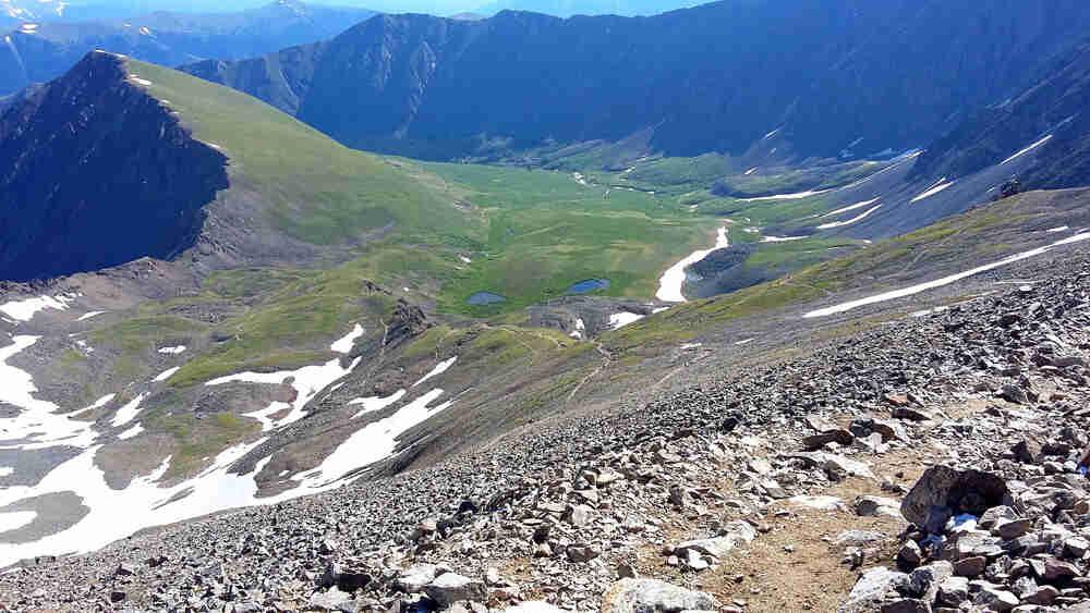
Grays Peak Trail
The Grays Peak National Recreation Trail starts from a trailhead near the old Stevens Mine in Stevens Gulch (center) and skirts past Kelso Mountain (left) before making a series of switchbacks up the northeast side of Grays Peak.
The Grays Peak National Recreation Trail starts in Stevens Gulch, just south of the Bakerville exit off Interstate 70 in Clear Creek County, and climbs roughly 3,000 feet in 3.5 miles to reach the summit of Grays Peak (14,278 feet) on the Continental Divide. First built by miner Richard Irwin in 1865 to accommodate tourists on horseback, the Grays Peak Trail has been one of the most popular Fourteener trails in Colorado for more than 150 years, providing easy access to Grays as well as nearby Torreys Peak (14,275 feet). In 1979 it was designated a National Recreation Trail, and today it is located in the Arapaho National Forest and maintained by the nonprofit Colorado Fourteeners Initiative (CFI).
Trail Origin
Native Americans probably climbed Grays and Torreys Peaks countless times over the centuries, and early prospectors almost certainly reached the summits sometime in 1860 or 1861. The first recorded ascents, however, belong to the botanist Charles Parry, who spent the summer of 1861 exploring the mountains near Berthoud Pass. He climbed the pair of mountains and named them for his botanist friends Asa Gray and John Torrey.
The development of trails and roads in the area started a few years later. In 1865, the prospectors Richard Irwin, John Baker, and William Fletcher Kelso discovered the Baker lode of silver ore on a smaller mountain that they called Kelso Mountain, just northeast of Grays and Torreys Peaks. Apparently unaware of the existing names, they also named Grays for Baker and Torreys for Irwin, but the original names won out by the 1870s. In 1865 Irwin built the Grays Peak Trail as a horse trail that ascended the northeast side of the mountain from Stevens Gulch.
Mining and Tourism
Mining and tourism combined to make Grays Peak a popular and easily accessible destination. The trail became more regularly used after the Baker Silver Mining Company bought the Baker Mine on Kelso Mountain in 1866 and built a wagon road to the mine. Completed in August 1867 at a cost of about $16,000, the Georgetown and Breckenridge Wagon Road ran from Georgetown to Bakerville, where the company built a mill for its ores, then turned up Quayle Creek and Stevens Gulch to access the mine.
Starting in 1867, then, it was possible to ride on horseback via the wagon road and Irwin’s trail from Georgetown to the Grays Peak summit, a trip that was described as easy when the weather was good and the ground was free of snow. As early as 1868, local newspapers reported “daily” ascents during the summer. The highest point on the Continental Divide in North America, Grays Peak was called “the dome of the continent” and soon became a standard tourist stop. “It was the great sight in all our Colorado travel,” the newspaper editor Samuel Bowles wrote in The Switzerland of America (1869).
As the trail became more heavily traveled, facilities sprang up to cater to tourists. By July 1870, an old boarding house in Bakerville had been improved and opened as a hotel for tourists headed to Grays Peak. Farther up, about where the mining road turned into a pack trail, was the Kelso Cabin, a guesthouse located near the Stevens Mine, not far from the present trailhead. Supposedly built by William Kelso at some point before the late 1870s and operated by a Mrs. Lane from about 1878 to 1883, the cabin could accommodate more than twenty guests, who could spend the night there before ascending Grays Peak in the morning.
The Grays Peak Trail attained even greater popularity as access became easier with the arrival of a railroad in the 1880s. In 1884 the Colorado Central Railroad extended its line from Silver Plume to Graymont, a station just east of Bakerville. The primary purpose of the railroad was to carry ore from the dozens of mines on and around Kelso Mountain, including the prolific Stevens Mine, for which Stevens Gulch is named. But the railroad also hoped to carry tourists; the name of the Graymont station was meant to attract people interested in climbing Grays Peak. In the late 1880s, Graymont boasted the Jennings Hotel, as well as a livery stable and two horse barns. The railroad offered a round-trip ticket from Denver to Graymont for $9, which included a horse and a guide to the summit.
Today
In the twentieth century, methods of accessing and climbing the Grays Peak Trail shifted from rails and horses to driving and hiking. By the early 1890s, tourists were being drawn to new attractions such as the Manitou and Pikes Peak Cog Railway. Meanwhile, silver mining went into a steep decline after the repeal of the Sherman Silver Purchase Act in 1893. The railroad stopped running from Silver Plume to Graymont. In 1898 the tracks were removed. The right-of-way became a wagon road, which was improved to a gravel highway by the 1930s, a paved highway by the 1950s, and eventually Interstate 70. The interstate has an exit at Bakerville, which is used primarily by hikers who drive the dirt road up Stevens Gulch to the Grays Peak trailhead near the old Stevens Mine.
Because of its proximity to Denver and the relative ease of the hike, the Grays Peak Trail has remained one of the most popular trails for “peak baggers” and others who enjoy outdoor adventures. To deal with the effects of increased use, in 2000–2002, CFI completed a major restoration of the trail, and CFI and other groups have continued to perform ongoing annual trail maintenance. In 2014 trail counters installed by CFI showed that an average of more than 100 people used the Grays Peak Trail each day in July and August, with peak usage of more than 400 hikers per day on many summer weekends.