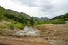
Until recently, the Animas River—known in Spanish as “El Río de las Ánimas,” or “The River of Lost Souls”—was one of only a few undammed rivers in southwestern Colorado. The Upper Animas River Canyon bears the legacy of the longest hard-rock mining…
Beginning in the central Rocky Mountains near Leadville, the Arkansas River runs nearly 1,500 miles across the Great Plains before emptying into the Mississippi River. The Arkansas is the lifeblood of cities and agricultural communities along its course,…
Two thousand feet deep, forty-eight miles long, and two million years old, western Colorado’s Black Canyon of the Gunnison is one of the most stunning geologic features in the American West. The fourteen miles along the Gunnison River have been protected…
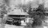
Cave of the Winds, located in Williams Canyon a few miles northwest of Colorado Springs, is one of the most popular tourist attractions in Colorado. Two schoolboys are credited with discovering the cave in 1880, though various legends hold that Ute and…
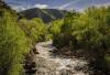
Clear Creek flows from the Continental Divide at Loveland Pass, eastward through a deep and wide glacial valley down to Idaho Springs, where the valley narrows and the stream gradient increases as it enters narrow, relatively undeveloped Clear Creek…
The Earth beneath the rugged mountains and serene plains of Colorado records an ancient saga. Broad tropical seas teemed with life, while reptiles roamed on shore. Continents converged and collided, building massive mountains, only to be torn apart by…
The Colorado is the premier river of the American Southwest. Rising in the mountains of Colorado and Wyoming, this river and its tributaries provide water and hydroelectric power for nearly 35 million people in the United States and Mexico, as well as…
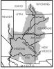
Colorado, “the Centennial State,” was the thirty-eighth state to enter the Union on August 1, 1876. Its diverse geography encompasses 104,094 square miles of the American West and includes swathes of the Great Plains, southern Rocky Mountains, and the…
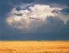
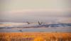
Eastern Colorado, bordered by the foothills of the Rocky Mountains on the west, Kansas on the east, and the corners of Nebraska and Oklahoma, constitutes a portion of the Great Plains. It is the agricultural heartland of Colorado. This semiarid region is…
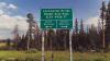
Established in 2019 as Colorado’s forty-second state park, Fishers Peak State Park covers 19,200 acres south of Trinidad near the New Mexico border. The mountainous area includes a cluster of hills and mesas that give way to the Colorado plains to the…
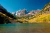
The Front Range is a corridor of the Rocky Mountains and surrounding land stretching 200 miles from the Wyoming border on the north to the Arkansas River on the south. The western border of the Front Range consists of a collection of high mountain ranges…
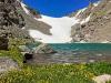
Snow in the high country sometimes accumulates faster than it melts, leading to the formation and continuation of glaciers. Colorado is home to seven glacial regions that reside mainly in central and northern Colorado. Each area sustains unique…
The story of irrigation in Colorado’s Grand Valley speaks volumes about the reciprocal relationship between land and community in the arid American West. Early white colonizers of Colorado’s Western Slope espoused concepts of landscape and water control…
The beautiful and imposing mountain scenery of Colorado’s Great Divide has led to the common belief that the state is home to a singular “Continental Divide.” The divide in Colorado, however, is only a piece of the larger Great Divide, a geologic crest…
The Gunnison River is a major tributary of the Colorado River, contributing about one-third of the Colorado’s flow at the Colorado-Utah state line. The basin drained by the Gunnison stretches from alpine meadows and forests along the Continental Divide…
The Manitou and Pikes Peak Cog Railway climbs the 8.9 miles to the 14,110-foot summit of Pikes Peak. The railway is the highest in North America and was built as a tourist attraction in the late nineteenth century. Other cog railways can be found on Mt…
From the sixteenth century to the mid-nineteenth, the king of Spain and the Mexican government awarded land grants to individuals and communities throughout the American Southwest. All seven of Colorado’s land grants, comprising more than 8 million acres…
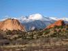
At the southern tip of Colorado’s Front Range, just west of the city of Colorado Springs, Pikes Peak is the most famous mountain in the state. The Fourteener is one of the most important peaks in Colorado history and plays an essential role in the state…
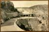
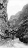
The Royal Gorge is a spectacular canyon along the Arkansas River near Cañon City in south-central Colorado. With a narrowest width of just 30 feet at the bottom of the canyon and a depth exceeding 1,200 feet in some places, the nearly ten-mile-long…
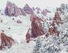
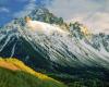
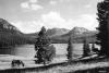
The San Juan Mountains are the largest mountain range by area in the Centennial State, spanning thirteen counties in southwestern Colorado. In addition to being the home of the Ute Indians for hundreds of years, the mountains intrigued Spaniards, lured…
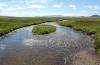
Covering nearly 8,000 square miles in southern Colorado, the San Luis Valley is the largest valley in the state and the largest high-altitude desert in North America. Known as “the Valley” by locals and other Coloradans, the San Luis Valley is bordered…
The South Canyon Fire began in early July 1994 on Storm King Mountain, in Garfield County west of Glenwood Springs. On July 6, high winds stoked the fire into a deadly conflagration that killed fourteen firefighters. Investigations of the disaster forced…
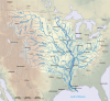
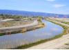
The South Platte River flows from its headwaters in the Mosquito Range west of South Park across Colorado’s northeastern plains. From downtown Fairplay to the Nebraska border at Julesburg, its course through Colorado is approximately 380.3 miles.
&…
The Flat Tops Wilderness covers more than 235,000 acres of remote mountains and forests in Garfield, Rio Blanco, and Eagle Counties on Colorado’s Western Slope. Its most popular natural feature is Trappers Lake, the state’s second-largest natural lake,…
“A Fantasy land,” “a mystique,” “a state of mind”—these are only some of the expressions used to describe the Western Slope of Colorado, commonly defined as the roughly one-third of the state that lies west of the Continental Divide. The serpentine…
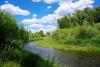
The Yampa River snakes 250 miles across northwestern Colorado, primarily in Routt and Moffat Counties. Its watershed encompasses approximately 8,000 square miles in Colorado and Wyoming; in Colorado, the river flows through Craig, Hayden, Milner, and…