Bureau of Reclamation in Colorado
Full Article
The United States Reclamation Service, later renamed the Bureau of Reclamation, was created in 1902 to advance settlement of the West through construction of large dams, reservoirs, canals, and other projects. Since then, the service has played an important role in the development of Colorado’s water resources. It has constructed sixteen projects in Colorado, improving water deliveries to irrigators, aiding in urban growth by supplying water and power to municipalities and industries, creating new recreational areas around its reservoirs, and providing flood control.
Uncompahgre and Grand Valley Projects
At first, the mission of the Reclamation Service focused on increasing settlement opportunities in the arid West. In Colorado, the Reclamation Service constructed two projects under this mandate: the Uncompahgre Project on the Uncompahgre and Gunnison Rivers and the Grand Valley Project on the Colorado River.
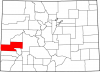
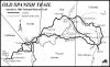
Irrigation development in the Uncompahgre River valley began during the early 1880s, shortly after the removal of the Ute tribe to Utah. Similar to other irrigation projects at that time, private enterprise took the lead in constructing facilities. Some believed the Uncompahgre River capable of irrigating 175,000 acres. Water supplies, however, failed to meet these expectations, and by 1890, fewer than 30,000 acres were irrigated. Developers made plans to construct a tunnel to divert water from the nearby Gunnison River to stabilize Uncompahgre River water supplies. Construction on the tunnel began in 1901, but the project was soon abandoned due to lack of funds.
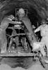
In 1903 the Reclamation Service took over the project, and construction of the first project feature—the Gunnison Tunnel—began in 1905. Tunnel construction faced many challenges, including high temperatures within the tunnel, carbon dioxide build-ups, water leakage, and multiple varieties of rocks to dig through. These difficulties resulted in the deaths of twenty-six workers. In 1909 the Reclamation Service completed work on the Gunnison Tunnel, and President William Howard Taft attended the tunnel’s official opening on September 23.
After the completion of the Gunnison Tunnel, the agency began work on the remaining project features, which included seven diversion dams and 128 miles of canals. Much of this work consisted of rehabilitation and improvement of existing facilities. By 1925 the Uncompahgre Project was essentially complete. The last major addition to the project came in 1934 with the construction of Taylor Park Dam and reservoir to shore up project water supplies. Located twenty miles upstream from the head of the Gunnison River, the dam was completed in 1937.
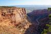
The Uncompahgre Project provides irrigation water for over 76,000 acres, producing a wide variety of crops. Over the course of the twentieth century, recreation and tourism—such as visits to the Black Canyon of the Gunnison or Taylor Park Reservoir—have grown to become important aspects of the local economy. In addition, project features have been singled out for their unique engineering features. For example, the Gunnison Tunnel, the longest of its kind at the time, was declared a National Historical Civil Engineering Landmark in 1972 and was listed on the National Register of Historic Places in 1979.
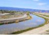
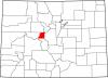
The Grand Valley Project is located in western Colorado in the area of Grand Junction, near the confluence of the Gunnison and Colorado Rivers. Early settlers in the 1880s found fertile land that responded well to irrigation and by 1886, 45,000 acres were irrigated. In 1907 valley residents requested that the RS improve existing facilities and provide new works to irrigate the higher benchlands.
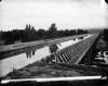
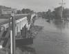
Construction began in October 1912. Project features included a fourteen-foot-high diversion dam on the Colorado River, four canals stretching over ninety miles, and three tunnels. The RS began work on the three tunnels, beginning with Tunnel No. 1, which was holed through in September 1913. Within two years, tunnels No. 2 and 3 were complete.
The main feature of the Grand Valley Project is the 14-foot high and 546-foot-long Grand Valley Diversion Dam. Dam construction began in 1913. The structure is a roller crest dam, consisting of six rollers seventy feet long and over seven feet in diameter. The rollers allow engineers to raise the water level behind the dam and divert water into the main canal. When raised, the rollers permit large objects to pass over the top of the dam. The RS completed construction in October 1916. At the time, the Grand Valley Diversion Dam was the largest roller crest dam in the world and today is listed on the National Register of Historic Places.
In May 1916 the Reclamation Service began water deliveries to irrigators, and by 1917, all project features were complete. With improved irrigation facilities, the amount of irrigated acreage slowly increased, and by 1921 project lands had risen to 21,290 acres. Over the course of the twentieth century that number increased, reaching a total of 34,160 acres in 1965. In March 1933 the Reclamation Service added a hydroelectric component to the project. Over time the delivery of water for municipal and industrial purposes increased in importance, serving growing communities and altering project purposes. Nevertheless, the project continues to aid irrigators in western Colorado, contributing to the success of agriculture.
Colorado River Storage Project
In November 1922 the multistate Colorado River Compact divided Colorado River water between the states in the upper and lower basins of the river. World War II, with its accompanying demographic growth in the Southwest, exponentially increased demands for water and power. As a result, Colorado, Wyoming, New Mexico, Utah, and Arizona signed the Upper Colorado River Basin Compact, dividing the waters of the Colorado River in 1947. With the compact in place, the Bureau of Reclamation (formerly the Reclamation Service) proposed an ambitious plan for the upper basin in 1948. The bureau’s plans included the construction of ten dams throughout the region to provide hydroelectricity and water storage for new and existing agricultural areas. In 1955 Congress approved the Colorado River Storage Project (CRSP), and initial appropriations went to the construction of four units, including the Curecanti (Aspinall) Unit on the Gunnison River.
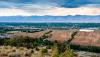
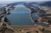
Located on a forty-mile stretch of the Gunnison in west-central Colorado, the Curecanti Unit consists of three dams: Blue Mesa, Morrow Point, and Crystal. The unit’s primary purpose is water storage for power production and to supply supplemental irrigation water, along with municipal and industrial water. The unit allows Colorado to use its allotment under the Colorado River Compact. Congress authorized construction of Blue Mesa and Morrow Point dams and power plants in 1959 and Crystal Dam in 1962.
Construction of Blue Mesa Dam began in 1961. Located thirty miles downstream from the town of Gunnison, Blue Mesa is an earth-fill embankment dam 390 feet high and 785 feet long at its crest. Its power plant consists of two 30,000-kilowatt generators. Reclamation completed construction in 1966, and the power plant began producing electricity in 1968.
Just twelve miles downstream, construction of Morrow Point Dam also began in 1961. Bureau of Reclamation engineers designed the dam as a thin-arch double-curvature concrete structure 468 feet high and 724 feet long at its crest. The Morrow Point Power plant is the first underground hydroelectric facility and consists of two 60,000-kilowatt generators. The bureau completed construction of the dam in 1968, and the power plant went online by 1971.
Located six miles downstream of Morrow Point Dam, preliminary work on Crystal Dam began in 1964. Originally planned as an earth-fill structure, the bureau changed the design to a double-curvature thin arch dam 323 feet high and 635 feet long at the crest. This design change delayed construction to 1973. The Crystal Dam Power Plant holds two 39,000-horsepower hydraulic turbines with a generating capacity of 28,000 kilowatts. The bureau completed dam construction in 1976 and finished the power plant in 1978.
The bureau designed the unit to work in unison to meet specific needs at certain times. Blue Mesa Dam is the primary storage facility, allowing its power plant to meet load requirements depending on customer needs. Morrow Point and Crystal dams maintain uniform stream flows that provide a steady production of electricity. During the irrigation season, these dams ensure water deliveries to area farmers. The proceeds from the sale of electricity help to repay construction costs and allow for the continuing development of Colorado’s water resources.
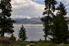
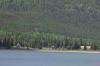
It took seventeen years to complete the Curecanti Unit, the last of the original CRSP units authorized by Congress in 1955. In 1980, the unit was renamed the Wayne Aspinall Unit in honor of long-serving Colorado congressman Wayne Aspinall, who had championed water reclamation projects in Colorado and throughout the West. Over time the Wayne Aspinall Unit has become an important feature of western Colorado’s outdoor recreation industry, providing multiple recreational activities such as camping, fishing, and hiking.
Fryingpan-Arkansas Project
During the second half of the twentieth century, irrigation development expanded throughout the Arkansas River valley. The bureau designed the Fryingpan-Arkansas Project to deliver supplemental irrigation water to Arkansas Valley farmers and provide municipal and industrial water to Front Range communities. When completed, the project consisted of six storage dams, seventeen diversion dams, two power plants, and hundreds of miles of canals, conduits, and tunnels.
The bureau began investigating ways to increase water supplies to the Front Range during the late 1940s. Citizens in western Colorado objected on the grounds that proposed diversion limited the potential growth of Western Slope communities. Proponents spoke of the desperate need for municipal water to keep up with growth. Contentious discussions lasted over ten years. The major stumbling block was the proposed Aspen Reservoir, which the citizens of Pitkin County vehemently opposed. In 1959 the contesting parties reached an agreement by dropping Aspen Dam in favor of Ruedi Dam on the Fryingpan River. In the summer of 1962 Congress authorized construction of a scaled-back project, named the Fryingpan-Arkansas Project.
The bureau’s construction of the project would take more than twenty years to complete and face changing American values concerning human relationship with the environment. Construction schedules were divided into four sections: West Slope, Buena Vista, Salida, and the Arkansas Valley. Over the length of development, the project went through many metamorphoses. Only two of the planned six power plants, Mount Elbert and Otero, were constructed. In total, the bureau built six storage dams—Ruedi, Sugar Loaf, Pueblo, Mt. Elbert Forebay, Twin Lakes, and Clear Creek—along with seventeen diversion dams and associated structures.
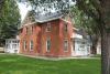
The Fryingpan-Arkansas Project was one of the first projects in which the Bureau of Reclamation had to consider environmental regulations. In 1969 Congress passed the National Environmental Policy Act that mandated that the bureau alter many project features. For example, the bureau relocated historic buildings in the town of Twin Lakes to avoid their destruction. In addition, it constructed tunnels instead of open canals across forest lands so as to not mar the natural scenery. Unforeseen results stemming from steadier water flows in the Arkansas River occurred when the river became a first-class trout stream and a popular attraction for whitewater rafting enthusiasts.
Construction of the Fryingpan-Arkansas Project ended in the early 1980s. Along with meeting environmental requirements, the twenty-year construction period saw changes in Front Range water needs. The region witnessed significant urban and suburban growth, along with rising demands for municipal and industrial water. As a result, significant amounts of water for Arkansas Valley agricultural lands were taken out of production.
The Bureau of Reclamation’s contributions to the development of Colorado’s water resources changed as the state’s needs changed. Early in the twentieth century, construction of the Uncompahgre and Grand Valley projects reflected needs to enhance and expand Colorado agriculture. By midcentury, multiple-use projects became the focus of the bureau’s efforts, diversifying water utilization. Both the Wayne Aspinall Unit and the Fryingpan-Arkansas Project represent this change in its mission and water-user requirements. During the latter half of the twentieth century, water resources development encompassed meeting multiple demands, such as irrigation, municipal and industrial uses, flood control, power development, and recreation. Significantly, these expansions in the Bureau of Reclamation’s mission mirrored Colorado’s transformation from a rural/agricultural base to an urban/industrial society.