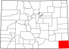
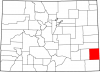
Baca County is a rural, agricultural county on the southern plains encompassing an area of 2,557 square miles in the southeast corner of Colorado. It borders Bent and Prowers Counties to the north, Las Animas County to the west, the state of Kansas to…
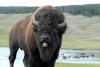
The American Plains Bison (Bison bison) are large mammals in the Bovidae family, recognizable for their large head, shaggy coats, pronounced hump, and close association with the American West. Bison are commonly and incorrectly referred to as …
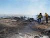
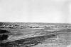
On June 10, 2008, lightning sparked the Bridger Fire in a US Army training area in southeast Colorado, about twenty-five miles south of La Junta. Also known as the Piñon Canyon Fire, the blaze went on to become a significant wildfire, burning 46,612…
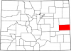
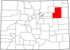
Cheyenne County is a sparsely populated county on Colorado’s eastern plains, covering 1,781 square miles. It is named for the Cheyenne, one of many nomadic Native American groups that lived and hunted bison in the area throughout the nineteenth century…
Colorado’s combination of high elevation, midlatitude, and continental interior geography results in a cool, dry, and invigorating climate. The average annual temperature for the state is 43.5 degrees Fahrenheit (F), which is 13.7 degrees below the…
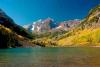
Colorado, “the Centennial State,” was the thirty-eighth state to enter the Union on August 1, 1876. Its diverse geography encompasses 104,094 square miles of the American West and includes swathes of the Great Plains, southern Rocky Mountains, and the…
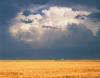
Eastern Colorado, bordered by the foothills of the Rocky Mountains on the west, Kansas on the east, and the corners of Nebraska and Oklahoma, constitutes a portion of the Great Plains. It is the agricultural heartland of Colorado. This semiarid region is…
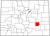
Formed in 1911, Crowley County covers 800 square miles on Colorado’s southeastern Great Plains near the Arkansas River. It is bordered to the north by Lincoln County, to the east by Kiowa County, to the south by Otero County, and to the west by Pueblo…
The tension between aridity and irrigated agriculture has been a defining characteristic of Colorado for much of its modern history. On average, the state receives less than fifteen inches of annual precipitation, making it the seventh driest state in…
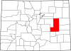
Kit Carson County, named for fur trapper and Army scout Kit Carson, covers 2,162 miles of the Great Plains in eastern Colorado. One of the state’s most productive agricultural counties, Kit Carson is bordered to the north by Yuma and Washington Counties,…
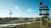
The Last Chance Fire started on June 25, 2012, when sparks from a motorist’s flat tire set the prairie ablaze near the town of Last Chance in eastern Colorado. The fire was 100 percent contained in nearly twenty-four hours, but in that time the wildfire…
Lincoln County, named after President Abraham Lincoln, covers 2,586 square miles of Colorado’s Great Plains southeast of Denver. It is bordered to the north by Washington County, to the east by Kit Carson and Cheyenne Counties, to the southeast by Kiowa…
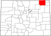
Logan County, named for Civil War General John A. Logan, covers 1,845 miles of the Great Plains in northeast Colorado. It is bordered to the north by the state of Nebraska, to the east by Sedgwick and Phillips Counties, to the southeast by Yuma County,…
The Medicine Lodge Treaties were a series of three treaties between the US government and the Comanche, Kiowa, Plains Apache, Southern Cheyenne, and Southern Arapaho American Indian nations, signed in October 1867 along Medicine Lodge Creek, south of…
Phillips County covers 688 square miles on the Great Plains of northeastern Colorado. It has a population of 4,349, more than half of whom live in the county seat of Holyoke. Other communities include Haxton (pop. 946) and Amherst (58). Frenchman Creek…
Prowers County covers 1,644 square miles of the Great Plains and Arkansas River valley in southeastern Colorado. The rectangular county is bordered to the north by Kiowa County, to the east by the state of Kansas, to the south by Baca County, and to the…
“The Great Die Up” is one of three nicknames for the winter of 1886–87, when hundreds of thousands of cattle across the Great Plains died in harsh weather. The event changed the cattle industry forever, ending the practice of open-range grazing. Ranchers…
Signed in 1851, the Treaty of Fort Laramie was made between the US government and several Indigenous nations of the Great Plains—including the Cheyenne, Arapaho, and Lakota—who occupied parts of present southern Wyoming and northern Colorado. The treaty…
Washington County, named for the first US president, is a county of 2,524 square miles on Colorado’s eastern Great Plains. It is bordered to the north by Logan County, to the east by Yuma County, to the south by Kit Carson and Lincoln Counties, and to…
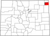
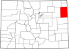
Yuma County covers 2,369 square miles in northeast Colorado. A part of the state’s Great Plains region, the county includes the lowest point in Colorado: 3,315 feet, along the Arikaree River at the Kansas border. Yuma County is bordered to the east by…
Early nineteenth century Army explorers Zebulon Pike and Stephen H. Long conceptualized the Great Plains east of the Rocky Mountains as the “Great American Desert.” Long’s report called it “unfit for cultivation,” while Pike compared it to “the sandy…