You are here

farming

Boggsville

Added by yongli on 11/05/2015 - 13:48, last changed on 08/12/2022 - 07:36

Boggs House

Share article to
Founded in 1866 near the confluence of the Arkansas and Purgatoire Rivers, Boggsville became the first permanent settlement in southeastern Colorado. Its residents pioneered irrigation and large-scale farming and ranching in the Arkansas Valley. The town flourished for a few years. In the 1870s,...

Chicago-Colorado Colony

Added by yongli on 12/06/2017 - 12:21, last changed on 11/02/2022 - 06:40
The Chicago-Colorado Colony (1871–73) established the city of Longmont near the confluence of St. Vrain and Left Hand Creeks in 1871. Financed by wealthy Chicagoans and consisting mostly of immigrants from the Midwest, the colony was an agricultural community that emphasized thrift, temperance, and...

Front Range

Added by yongli on 01/23/2017 - 16:06, last changed on 12/11/2022 - 09:42
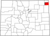
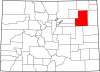
The Front Range is a corridor of the Rocky Mountains and surrounding land stretching 200 miles from the Wyoming border on the north to the Arkansas River on the south. The western border of the Front Range consists of a collection of high mountain ranges, from the Medicine Bow and Laramie Mountains...

Oliver Toussaint Jackson

Added by yongli on 09/29/2016 - 14:47, last changed on 11/11/2019 - 10:24
Oliver Toussaint “O. T.” Jackson (1862–1948) was an entrepreneur and prominent member of black communities in Denver and Boulder during the late nineteenth and early twentieth centuries. In 1910 he founded Dearfield , an-all black agricultural settlement some twenty-five miles southeast of Greeley...

Phillips County

Added by yongli on 09/30/2016 - 11:11, last changed on 11/02/2022 - 16:38
Phillips County covers 688 square miles on the Great Plains of northeastern Colorado. It has a population of 4,349, more than half of whom live in the county seat of Holyoke . Other communities include Haxton (pop. 946) and Amherst (58). Frenchman Creek is the only source of surface water for the...

Washington County

Added by yongli on 09/30/2016 - 11:23, last changed on 11/02/2022 - 16:38
Washington County, named for the first US president, is a county of 2,524 square miles on Colorado’s eastern Great Plains . It is bordered to the north by Logan County , to the east by Yuma County , to the south by Kit Carson and Lincoln Counties, and to the west by Arapahoe , Adams , and Morgan...

Yuma County

Added by yongli on 09/30/2016 - 12:30, last changed on 11/02/2022 - 16:38
Yuma County covers 2,369 square miles in northeast Colorado. A part of the state’s Great Plains region, the county includes the lowest point in Colorado: 3,315 feet, along the Arikaree River at the Kansas border. Yuma County is bordered to the east by Cheyenne County, Kansas, to the south by Kit...

“Great American Desert”

Added by yongli on 09/30/2016 - 09:37, last changed on 11/02/2022 - 12:43
Early nineteenth century Army explorers Zebulon Pike and Stephen H. Long conceptualized the Great Plains east of the Rocky Mountains as the “Great American Desert.” Long’s report called it “unfit for cultivation,” while Pike compared it to “the sandy deserts of Africa.” The myth of the Great...
Subscribe to farming