Weld County
Full Article
Weld County
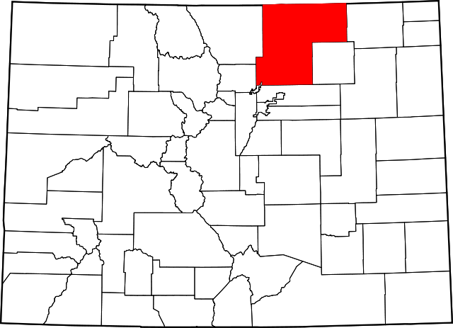
One of Colorado's original seventeen counties, Weld County covers 4,017 square miles in northeastern Colorado and is home to more than 250,000 people.
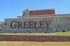
Weld County is the largest county in northeastern Colorado, covering 4,017 square miles of the Great Plains and the South Platte River valley. One of the original seventeen counties in the Colorado Territory, it is named for Louis Ledyard Weld, the first territorial secretary. The county is bordered to the north by the states of Wyoming and Nebraska, to the east by Logan and Morgan Counties, to the south by Adams and Broomfield Counties, and to the west by Boulder and Larimer Counties. The county seat of Greeley lies near the confluence of the South Platte and Cache la Poudre Rivers, at the intersection of US Routes 34 and 85. Greeley is known for its farming and ranching community and is home to the University of Northern Colorado.
A major agricultural county, Weld has a population of 252,825. More than a third of the population resides in Greeley, while the rest is spread out amongst smaller towns such as Fort Lupton and the county’s numerous farms and ranches. Interstate 25 runs through the western part of the county, while the Pawnee National Grassland occupies the sparsely populated land to the north and northeast.
Native Americans
The South Platte valley allowed many Plains Indian groups to hunt and trade with each other in what is now Colorado. After obtaining horses from the Spanish, the mountain-dwelling Utes began hunting bison in the Weld County area. Traveling south from Wyoming in the early 1700s, the Comanche also briefly inhabited the area before moving on to the Arkansas Valley. Pawnees also began to range into the Weld County area by 1719, prodded by their French trading partners to the east. The Cheyenne and Arapaho arrived in the early nineteenth century, driven from the upper Midwest by the Lakota. Like the Comanche farther south, the two groups relied on the power of the horse, the abundance of buffalo, and a robust trade network to survive and dominate Colorado’s northern plains. Soon after they arrived, the Arapaho and Cheyenne formed an alliance. They were among the first native groups to trade with whites in Colorado.
Europeans
The first European to enter the Weld County area was the Spaniard Don Pedro de Villasur in 1720, who sought to establish trade with Native Americans. Following the South Platte River out of its canyon near present-day Colorado Springs, he led forty-two Spanish soldiers, sixty Native American allies, a priest, an interpreter, and a few settlers past the mouth of the Cache la Poudre River and into western Nebraska. There, the expedition met a quick demise in a raid by Pawnees, apparently egged on by their French allies. After losing all but thirteen of his men, Villasur fled back to Mexico City.
The French brothers Pierre and Paul Mallet traversed the area in 1739, following the South Platte into the Rockies on their way to Taos, New Mexico. They were the first to call the river “Platte,” French for “flat” or “platelike.” Judging by their presence elsewhere on the plains and along the Front Range, French trappers and traders may have frequented the Weld County area in the late eighteenth century and early nineteenth century.
Americans
In 1820 the American explorer Stephen H. Long and his expedition made a brief stop in the Weld County area. Long’s expedition was tasked with mapping the South Platte River, and in July he set up camp just south of where it meets the Cache la Poudre River near present-day Greeley. The expedition went on to explore the St. Vrain and Big Thompson Rivers to the west.
In 1825 the seventy members of the William H. Ashley trapping party were the first whites to explore the Cache la Poudre river valley. The men were headed toward a rendezvous point along the Green River in Wyoming when a snowstorm stopped them for two weeks near present-day Greeley, giving rise to one of the stories about how the Cache la Poudre got its name - the party allegedly buried gunpowder and supplies near the river, naming it the “Cache la Poudre,” French for “powder cache.” The story is one of many unverified accounts of how the river got its name. In the ensuing decades, many of Ashley’s party would return to claim land in the Weld County area.
Trading Posts
The Long and Ashley expeditions, as well as the opening of the Santa Fé Trail to Americans in 1821, paved the way for the establishment of trading posts in the Weld County area. Louis Vasquez from St. Louis built the first one in 1835 along the South Platte near present-day Platteville. In exchange for buffalo robes, Vasquez gave the Cheyenne and Arapaho blankets, kettles, guns, knives, ammunition, and other items. The success of Fort Vasquez prompted the establishment of several competing forts over the next two years.
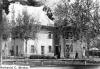
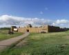
In 1836 Lancaster Lupton, a former army lieutenant who had served on the frontier and recently joined the fur trade, established Fort Lupton along the South Platte River northeast of present-day Denver. Lupton married a Cheyenne woman named Tomasina, and the trading post prospered until 1844, when competition from other forts forced Lupton’s out of business. He and his wife spent five years in southern Colorado before heading to Arcata, California, in 1849 to join the gold rush.
Not to be outdone by these two newcomers to the Colorado fur trade, the well-established Bent, St. Vrain and Company built Fort St. Vrain on the South Platte in 1836. Located just north of Fort Vasquez, Fort St. Vrain was operated until its closure in 1847 by Marcellin St. Vrain, Ceran St. Vrain’s younger brother.
The establishment of Forts Vasquez, Lupton, and St. Vrain on the South Platte placed significant pressure on the buffalo population, as the Cheyenne and Arapaho hunted more than they needed in order to meet traders’ demand for robes and their own desire for guns, tools, and ammunition. This early exploitation would prove a critical first step toward the buffalo’s demise, as it reduced the population just before a period of overhunting by the Comanche to the south and a fifteen-year dry spell that began in 1845.
In 2012 the South Platte Valley Historical Society completed a rebuild of Lancaster Lupton’s fort, a project twenty-four years in the making. Rebuilding the fort was the impetus for the society’s formation in 1988, and the new fort is now the centerpiece of society’s 100-acre history park on the north side of Fort Lupton.
Treaties
After the traders came the gold seekers—first on their way to California after 1849, and then to the Front Range after gold was found west of present-day Denver in 1858. In between those years, the Treaty of Fort Laramie (1851) and the Treaty of Fort Atkinson (1853) had supposedly guaranteed that Cheyenne and Arapaho lands north of the Arkansas would remain free of white settlers. Congress did not ratify the 1851 treaty, and it was not enforced during the Colorado Gold Rush of 1858–59, when whites poured into Cheyenne and Arapaho territory.
At this time a handful of whites, including famed Weld County cattleman John Wesley Iliff, decided to forego gold digging and set up ranches. These would-be ranchers, prospectors, and settlers streamed west along the South Platte, killing game, trampling grass, and consuming precious timber and other resources that Native Americans relied on. Facing starvation, the Cheyenne and Arapaho resumed raiding, which only increased tension with the United States.
Newspaper editor and western booster Horace Greeley visited the Cache la Poudre valley in 1859 and became convinced that the area, once properly irrigated, would make excellent farmland. But the slaughter of peaceful Cheyenne and Arapaho in the Sand Creek Massacre of 1864 prompted an all-out war between Plains Indians and the US government. Greeley would have to wait until after the Cheyenne and Arapaho were removed to Oklahoma under the Medicine Lodge Treaty (1867) to start his colony.
Early Communities
The first Territorial Legislature created Weld County in 1861. It initially occupied some 10,000 square miles, nearly the entire northeast quadrant of the new territory. By 1900 the county had shrunk close to its current size after the creation of Washington, Morgan, and Logan Counties in 1887 and Yuma County in 1889. In 2001 the city and county of Broomfield split from Weld County.
In December 1869, Nathan C. Meeker, Greeley, and Robert A. Cameron organized the Union Colony Association. In New York, they recruited members to pool money to build a farming colony in Colorado. By the following spring, they had purchased some 12,000 miles of land along the Cache la Poudre from the Denver Pacific Railroad. In June 1870, just after the railroad completed a line from Cheyenne to Denver, Meeker and several hundred initial settlers founded the town of Greeley. With the help of the rail line, the colony managed to attract hundreds of new residents by the end of the month. Greeley was designated the county seat in 1877.
Unlike the mining-centric towns that had sprung up to the west, Greeley had no saloons or liquor stores; its founders had imagined it as an orderly place where hardworking farm families could prosper in peace. The first irrigation ditch was finished by the end of the summer, and another was completed early the next year. The ditches were the first to be dug in the west for the sole purpose of agriculture, and they combined to irrigate some 60,000 acres. A drought in 1874 convinced Union Colony officials to create the first of many private irrigation companies in Colorado. Other states, most notably California, adopted this strategy.
Meanwhile, in 1872 the McKissick brothers, veterans of a local militia that fought Native Americans in the mid-1860s, opened one of the state’s first coal mines in southwestern Weld County. By 1907 the brothers’ land belonged to Ohio brothers Jacob and David Firestone, who opened the Firestone coal mine. The town of Firestone sprang up around the mine in 1908, and five coal mines remained in operation there until 1947.
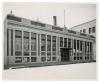
With the goal of training teachers for the state’s public schools, the State Normal School opened in Greeley on October 6, 1890. Initially offering two-year degree programs, the school began offering four-year degrees around the turn of the century, and in 1911 changed its name to Colorado State Teachers College. The college changed names again with the addition of a graduate program in 1935, becoming the Colorado State College of Education (shortened to Colorado State College in 1957). In 1970 it received its current name, University of Northern Colorado, to reflect more than thirty years of continued growth.
Farming and Ranching
By the turn of the century, farming and ranching spurred Weld County’s population to grow to 16,808. The expansion of irrigation networks turned potatoes and alfalfa into cash crops, while more than 90,000 sheep joined the cattle herds of the ranching industry. But the major cash crop of the early twentieth century was the sugar beet. Changes in the American diet led to increased demand for cooking and table sugar, but Weld County farmers were initially reluctant to plant sugar beets because there was no facility nearby that could process the crop and extract the sugar. This changed in 1901, when the Great Western Sugar Beet Company opened processing plants in Eaton and Greeley. Another processing plant opened in Windsor in 1904.
Sugar beet cultivation required intensive manual labor, and farmers consistently experienced labor shortages. In the early years of the industry, farmers hired Japanese and German Russian laborers, but many of them eventually moved on to start farms of their own. The German Russian labor pool was further diminished by immigration restrictions during World War I. Meanwhile, hundreds of Mexican immigrants, many of whom had farming experience, were coming to Colorado in search of work. In Weld County these newcomers found seasonal jobs on beet farms; the Great Western Sugar Company, for example, built thirteen communities in Weld County and elsewhere across the plains to attract farm labor. Although many immigrants returned to Mexico after the harvest, some stayed, and many of their families formed the base of Latino communities in places such as Greeley and Fort Lupton.
While Weld County farmers embraced the sugar beet boom, one local family fostered a revolution in ranching. The Monforts, one of the most prominent cattle-raising families in the nation, moved to Greeley in 1906. When Warren Monfort returned from service in World War I, he purchased some cattle to help his father’s struggling poultry farm. Instead of letting the cattle graze on the open range, he began feeding them with surplus crops. This innovative practice saved the family farm, and after several years of growth Monfort founded Monfort, Colorado, Inc. in 1930. Because he changed his cattle’s diet from grass to grain, and then to sugar beets, Monfort was also able to trade the open range for the feedlot. Feeding cattle in large pens close to the farm allowed him to provide fresh beef to consumers year-round. This method, combined with a rising demand for beef from the late 1940s, made his company extraordinarily successful: by 1950 his cattle herd numbered 8,000 and helped him earn a profit of $1 million.
In 1960 Monfort’s company partnered with Capital Packing, Inc. to build a meat-packing plant in Greeley. After a slow start, Monfort bought Capital’s share and ramped up production; by cutting out the middlemen of the packers, Monfort again introduced a revolutionary practice to the beef industry. By the end of the decade, Monfort’s packing plant employed 931 people and had sold almost $162 million in beef. His feedlot held some 100,000 cattle, making it the largest in the world. In 1969 the company, now under the leadership of Warren’s son Kenneth, bought out another middleman, the Mapelli Brothers Food Distribution Company, an act that lowered production costs even further.
After the company went public in 1970, Monfort’s Greeley feedlot had grown so large that residents began to complain about its acrid smell. The company responded by closing the Greeley lot and opening another in Kersey. Monfort lost a significant amount of money in the early 1980s due to tornados and labor disputes, but soon regained its profitability before it was bought out by ConAgra Foods in 1987. The Monfort family has since made major donations to Colorado universities, including $10.5 million to found the business school at the University of Northern Colorado in 1999 and a $5 million pledge to Colorado State University in 2002.
Energy Industry
Weld County sits atop the enormous Niobrara Shale formation, a subterranean rock formation containing oil and natural gas at depths between 3,000 and 14,000 feet. The county currently hosts approximately 20,000 oil and gas wells, more than any other county in the state. The energy industry is a huge contributor to the local economy; for example, since the beginning of the oil shale boom in 2010, Weld County employment has risen 21.5 percent. In 2011 the county collected $52 million in taxes from a single oil and gas producer. That money, like other revenue collected from the energy industry, has helped support Weld County schools, libraries, fire districts, and other services.
Yet the economic benefits of oil drilling and hydraulic fracturing—in which a highly pressurized mix of water, sand, and chemicals is blasted into the ground to crack subterranean rock formations and release natural gas—come with concerns about the industry’s impact on public health and the environment.
While environmental groups and citizens have reported a variety of negative side effects from the industry, the best-documented concerns—summarized in a 2014 report from the Natural Resources Defense Council—are leakage of cancer-causing chemicals such as benzene and air pollution caused by rigs and other heavy equipment. Additionally, in June 2015, a draft assessment of hydraulic fracturing’s potential effects on drinking water by the Environmental Protection Agency (EPA) concluded that “there are above and below ground mechanisms by which hydraulic fracturing activities have the potential to impact drinking water resources.” Weld County citizens’ concerns about the oil and gas industries were recorded in the county’s 2013 Community Health Survey; in 900 comments from more than 550 residents, “fracking/oil & gas” and “environmental safety” were among the most commonly addressed topics.
As it is elsewhere in Colorado and the nation, the conversation regarding hydraulic fracturing and the energy industry in Weld County remains highly polarized: energy companies and industry reps deny the harmful effects of extraction and claim that any kind of stringent regulation will hurt local economies, while environmentalists and others concerned about public health and the environment push for more transparency from companies and stricter regulations from the state and federal governments.
Natural Features and Disasters
After the disastrous Dust Bowl of the 1930s, which resulted in the degradation of thousands of acres of grasslands across the central United States, Congress took action to restore and preserve large sections of native prairie. The Bankhead-Jones Farm Tenant Act of 1937 allowed the federal government to purchase and restore damaged land, and in 1960 the government created seventeen national grasslands, including the Pawnee National Grassland (PNG) in northern Weld County. The grassland is named for the Pawnee people, a group of Plains Indians who frequented the eastern Colorado plains from the sixteenth to the mid-nineteenth century.
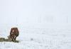
The PNG covers 193,060 acres of short-grass prairie. The area is home to Colorado’s state bird, the lark bunting, as well as hawks, falcons, and swallows, making it a premier destination for birdwatchers. The two Pawnee Buttes rise 300 feet above the grassland and can be accessed via hiking and horseback trails.
Within the boundaries of the grassland, some eighty-eight ranchers still graze about 8,000 head of cattle on private lands; the ranchers also have grazing rights on the grassland but must adhere to US Forest Service regulations.
After several days of heavy rain beginning on September 9, 2013, Weld County was one of fourteen Colorado counties to experience historically destructive flooding. Within Weld County alone, flood waters from the South Platte, Cache la Poudre, and other rivers damaged more than 3,000 homes and 122 bridges, washed out 654 miles of roads, and inundated 2,377 parcels of farmland. Immediately after the floods, Governor John Hickenlooper declared a state of emergency and funneled $6 million in state funds to pay for flood response and recovery.
Recovery efforts were still going on when the Cache la Poudre flooded again in June 2014. Although shorter lasting and less destructive than those in 2013, the 2014 floods still damaged about two dozen homes and businesses in Greeley.