Old Spanish National Historic Trail
Full Article
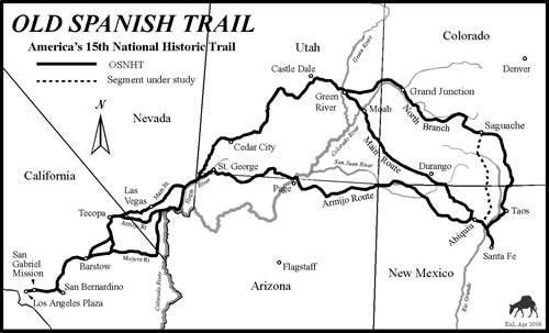
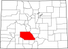
Old Spanish Trail Map
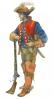
The Old Spanish Trail was designated a national historic trail by an act of Congress in 2002. From 1829 to 1848, the major trade route extended 2,700 miles between Santa Fé de Nuevo Mexico (Santa Fe, New Mexico), and Alta California (Los Angeles, California). Mexico’s independence from Spain in 1821 allowed the trail to be opened to California, initiating trade between Missouri and Santa Fé. California was seen as an important market, and annual trade caravans carried woven woolen goods from Nuevo Mexico and returned with mules and horses. Native Americans captured while traveling in both directions were readily sold as slaves in California and Nuevo Mexico. The Ute people were also active participants in the horse and slave trades of the time, though they used the trail less frequently.
Origins
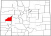
The Old Spanish Trail in Colorado was part of three trail systems on very different routes with individual histories. The Armijo Route was used only once by a party led by Antonio Armijo in 1829; it clipped the far southwestern corner of the state. Beginning in 1831, the main Spanish Trail traversed a larger portion of southwestern Colorado before entering Utah and crossing the Colorado River at Moab, Utah, en route to California. The portion in Colorado was initially traveled by Juan de Rivera in 1765 and by the Dominguez-Escalante expedition in 1776.
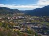
The North Branch is the longest of the routes in Colorado. It extended northward through Taos, New Mexico, through the San Luis Valley, westward across Cochetopa Pass, over Cerro Summit into the Uncompahgre Valley, and across the Uncompahgre River near the Ute Indian Museum in Montrose. It then headed northward to a crossing of the Gunnison River northwest of Delta, continued north along the general course of present US Highway 50, crossed the Colorado River at Grand Junction, and continued into Utah near the spot where Interstate 70 enters the state.
The North Branch intersected the main Spanish Trail in Utah’s Cisco Desert before crossing the Green River. A variant of the trail took a more northerly course after crossing Cochetopa Pass, passing through present-day Gunnison, then taking a route through present-day Crawford and down the North Fork of the Gunnison River, where it joined the more frequently used route northwest of Delta. The North Branch was the trail used by trappers to access large areas of western Colorado and eastern Utah. The trappers’ primary destinations were Antoine Roubidoux’s trading posts at Fort Uncompahgre (near present-day Delta), Fort Uintah (in Utah’s Uintah Basin), and the Salt Lake Valley. New Mexicans also used the North Branch as a principal route for trade with the Utes.
End of International Trade and Modern Development
The US acquisition of New Mexico as a result of the Mexican-American War (1846–48) ended use of the Spanish Trail as a trade route between New Mexico and California. Some used the main trail to reach California during the 1849 gold rush, and thousands of sheep were driven to California from New Mexico in the early 1850s to feed hungry miners. Also in the 1850s, the trail was used by government exploration expeditions. Explorations were undertaken in 1853 to identify a route for a transcontinental railroad. Traveling along the North Branch in that year was Colonel Edward Beale, followed a few months later by John W. Gunnison and thenJohn C. Frémont. In 1858, portions of the North Branch were improved by Colonel William Loring as part of a military wagon road connecting Utah’s Salt Lake Valley to Fort Union, New Mexico. The main trail was used by the Macomb expedition in 1859 in its journey to find the junction of the Colorado and Green Rivers.
Thereafter, more of the trail was improved as wagon roads for local travel and later as county roads and highways for automobiles. Where it has not been improved it is difficult, if not impossible, to see the original trail route. In 2010 the Bureau of Land Management funded a project to identify portions of the trail on its land. This resulted in more accurate knowledge of the route, and seventy-six miles of the trail in Colorado were precisely mapped and described.
10th Grade
The Old Spanish Trail was designated a national historic trail by an act of Congress in 2002. From 1829 to 1848, this major trade route extended 2,700 miles between Santa Fé de Nuevo Mexico (Santa Fe, New Mexico), and Alta California (Los Angeles, California). The trail was opened to California when Mexico won independence from Spain in 1821. California was an important market, and annual trade caravans carried woven woolen goods from Nuevo Mexico and returned with mules and horses. Captured Native Americans were readily sold as slaves in California and Nuevo Mexico. The Ute Indians also participated in the horse and slave trades, though they used the trail less frequently.
Origins
The Old Spanish Trail in Colorado was part of three trail systems on very different routes. The Armijo Route was used only once by a party led by Antonio Armijo in 1829; it clipped the far southwestern corner of the state. Beginning in 1831, the main Spanish Trail traversed a larger portion of southwestern Colorado before entering Utah and crossing the Colorado River at Moab, Utah, en route to California. The portion in Colorado was initially traveled by Juan de Rivera in 1765 and by the Dominguez-Escalante expedition in 1776.
The North Branch is the longest of the routes in Colorado. It extended north through Taos, New Mexico, through the San Luis Valley, then west across Cochetopa Pass, over Cerro Summit, and into the Uncompahgre Valley. It crossed the Uncompahgre River near present-day Montrose and then headed north to cross the Gunnison River northwest of Delta. Continuing north along the general course of present US Highway 50, it crossed the Colorado River at Grand Junction, and continued into Utah near the spot where Interstate 70 enters the state.
The North Branch intersected the main Spanish Trail in Utah’s Cisco Desert before crossing the Green River. Another part of the trail took a more northerly course after crossing Cochetopa Pass, passing through present-day Gunnison, then taking a route through present-day Crawford and down the North Fork of the Gunnison River, where it joined the more frequently used route northwest of Delta. The North Branch was the trail trappers used to access parts of western Colorado and eastern Utah. The trappers’ primary destinations were Antoine Roubidoux’s trading posts at Fort Uncompahgre (near present-day Delta), Fort Uintah (in Utah’s Uintah Basin), and the Salt Lake Valley. New Mexicans also used the North Branch as a principal route for trade with the Utes.
End of International Trade and Modern Development
After the United States acquired New Mexico because of the Mexican-American War (1846–48), the Spanish Trail ceased to be a major trade route between New Mexico and California. Some used the main trail to reach California during the 1849 Gold Rush, and thousands of sheep were driven to California from New Mexico in the early 1850s to feed hungry miners. Also in the 1850s, the trail was used by government explorers. Expeditions to identify a route for a transcontinental railroad began in 1853. Traveling along the North Branch that year was Col. Edward Beale, followed a few months later by John W. Gunnison and then John C. Frémont. In 1858 portions of the North Branch were improved by Col. William Loring as part of a military wagon road connecting Utah’s Salt Lake Valley to Fort Union, New Mexico. The main trail was used by the Macomb expedition in 1859 in its journey to find the junction of the Colorado and Green Rivers.
More of the trail was improved as wagon roads for local travel, and later as county roads and automobile highways. Where it has not been improved it is difficult, if not impossible, to see the original trail route. In 2010 the Bureau of Land Management funded a project to identify portions of the trail on its land. This resulted in more accurate knowledge of the route, and seventy-six miles of the trail in Colorado were mapped and described.
8th Grade
The Old Spanish Trail was made a national historic trail by an act of Congress in 2002. From 1829 to 1848, the trail was the major trade route between Santa Fé de Nuevo Mexico (Santa Fe, New Mexico), and Alta California (Los Angeles, California). The trail was opened to California after Mexico won independence from Spain in 1821. California was an important market, and annual trade caravans carried woven woolen goods from Nuevo Mexico and returned with mules and horses. Native Americans captured while traveling in both directions were readily sold as slaves in California and Nuevo Mexico. The Ute Indians were also active participants in the horse and slave trades, though they used the trail less often.
Origins
The Old Spanish Trail in Colorado was part of three trail systems on very different routes. The Armijo Route was used only once by a party led by Antonio Armijo in 1829. It cut through the far southwestern corner of the state. Beginning in 1831, the main Spanish Trail passed through a larger portion of southwestern Colorado before crossing the Colorado River at Moab, Utah, on the way to California. The portion in Colorado was initially traveled by Juan de Rivera in 1765 and by the Dominguez-Escalante expedition in 1776.
The North Branch is the longest of the routes in Colorado. It extended northward through Taos, New Mexico, through the San Luis Valley, and then west across Cochetopa Pass, over Cerro Summit, and into the Uncompahgre Valley. It crossed the Uncompahgre River near present-day Montrose and then headed north to cross the Gunnison River northwest of Delta. Continuing north along present US Highway 50, it crossed the Colorado River at Grand Junction and continued into Utah near the spot where Interstate 70 enters the state.
The North Branch intersected the main Spanish Trail in Utah’s Cisco Desert before crossing the Green River. Another part of the trail took a more northerly course after crossing Cochetopa Pass, passing through present-day Gunnison, then taking a route through present-day Crawford and down the North Fork of the Gunnison River, where it joined the more frequently used route northwest of Delta. The North Branch was the trail trappers used to access parts of western Colorado and eastern Utah. The trappers’ primary destinations were Antoine Roubidoux’s trading posts at Fort Uncompahgre (near present-day Delta), Fort Uintah (in Utah’s Uintah Basin), and the Salt Lake Valley. New Mexicans also used the North Branch as a principal route for trade with the Utes.
End of International Trade and Modern Development
When the United States acquired New Mexico because of the Mexican-American War (1846–48) the Spanish Trail ceased to be a major trade route between New Mexico and California. Some used the main trail to reach California during the 1849 Gold Rush, and thousands of sheep were driven to California from New Mexico in the early 1850s to feed hungry miners. Also in the 1850s, the trail was used by government explorers. Expeditions to identify a route for a transcontinental railroad began in 1853. Col. Edward Beale traveled along the North Branch that year. He was followed a few months later by John W. Gunnison and then John C. Frémont. In 1858 portions of the North Branch were improved by Col. William Loring as part of a military wagon road connecting Utah’s Salt Lake Valley to Fort Union, New Mexico. The main trail was used by the Macomb expedition in 1859 in its journey to find the junction of the Colorado and Green Rivers.
Other parts of the trail were improved as wagon roads for local travel, and later as county roads and automobile highways. Where it has not been improved it is difficult, if not impossible, to see the original trail route. In 2010 the Bureau of Land Management funded a project to identify portions of the trail on its land. This resulted in more accurate knowledge of the route, and seventy-six miles of the trail in Colorado were mapped and described.
4th Grade
The Old Spanish Trail was made a national historic trail by an act of Congress in 2002. From 1829 to 1848, the trail was a major trade route between Santa Fé de Nuevo Mexico (Santa Fe, New Mexico), and Alta California (Los Angeles, California). Trade between Missouri and California started in 1821, when Mexico won independence from Spain. California was an important market. Each year, trade caravans carried woven woolen goods from Nuevo Mexico and returned with mules and horses.
Origins
The Old Spanish Trail in Colorado was part of three trail routes. The Armijo Route was used only once by a party led by Antonio Armijo in 1829. It cut through the far southwestern corner of the state. In 1831 the main Spanish Trail went by a large part of southwestern Colorado and crossed the Colorado River at Moab, Utah, on the way to California. This part of Colorado was first traveled by Juan de Rivera in 1765 and by the Dominguez-Escalante expedition in 1776.
The North Branch is the longest of the routes in Colorado. It went north through Taos, New Mexico and through the San Luis Valley. Then it turned west across Cochetopa Pass and over Cerro Summit into the Uncompahgre Valley. The trail then went across the Uncompahgre River near the Ute Indian Museum in Montrose. It headed north to a crossing of the Gunnison River northwest of Delta and then went north along the present US Highway 50. Finally, it crossed the Colorado River at Grand Junction, and continued into Utah near the spot where Interstate 70 enters the state.
The North Branch crossed the main Spanish Trail in Utah’s Cisco Desert before crossing the Green River. A different part of the trail went north after crossing Cochetopa Pass, passing through present-day Gunnison. Then it went through present-day Crawford and down the North Fork of the Gunnison River. There, it joined a well-used route northwest of Delta. The North Branch was the trail that trappers used to get to parts of western Colorado and eastern Utah. The trappers were headed to Antoine Roubidoux’s trading posts at Fort Uncompahgre (near present-day Delta), Fort Uintah (in Utah), and the Salt Lake Valley. New Mexicans also used the North Branch as a main route for trade with the Utes.
End of International Trade and Modern Development
When the United States got New Mexico after the Mexican American War (1846–48) it ended the use of the Spanish Trail as a trade route. Some still used the main trail to reach California during the 1849 Gold Rush. Thousands of sheep were driven to California from New Mexico in the early 1850s to feed hungry miners. In the 1850s, the trail was used by explorers. Expeditions to find a route for a transcontinental railroad began in 1853. Traveling along the North Branch that year was Col. Edward Beale, followed a few months later by John W. Gunnison and then John C. Frémont.
After 1859, the trail was used as wagon roads for local travel and later as county roads and automobile highways. In 2010 the Bureau of Land Management funded a project to identify portions of the trail on its land.