Montezuma County
Full Article
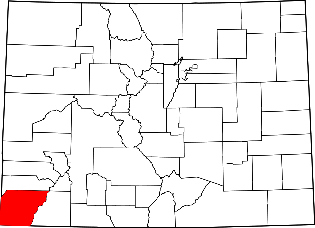
Montezuma County
Montezuma County, home of Mesa Verde National Park, was established in 1889.
Montezuma County, famous for the ancient Native American ruins at Mesa Verde, is the southwesternmost county in Colorado. The county covers 2,040 square miles of the Colorado Plateau, and has the distinction of bordering Utah, New Mexico, and Arizona. It is known as the Four Corners region, where the boundaries of four states intersect. Montezuma County is surrounded by three different San Juan Counties: San Juan County, Colorado to the northeast; San Juan County, New Mexico to the south; and San Juan County, Utah to the west. Dolores County, Colorado, lies along its northern border and La Plata County along its eastern. The county’s southwest corner touches Apache County, Arizona.
When the county was established in 1889, the ruins within its borders were thought to be of Aztec origin. Thus, Montezuma County is named after the Aztec emperor Moctezuma II, and its county seat, Cortez, is named after the Spanish conquistador who vanquished him. Most of the county’s ancient Native American ruins are located in Mesa Verde National Park in the southeast and Canyons of the Ancients National Monument in the west. In addition, Hovenweep National Monument lies just over the county’s western border in Utah.
The Ute Mountain Ute Reservation and its capital, Towaoc, are located in southern Montezuma County. Towaoc—a word that means “just fine”—has a population of 1,087; Native Americans make up 11 percent of the county’s 25,772 residents. Cortez has a population of 8,482 and sits in central Montezuma County at the juncture of US Routes 491 and 160 and State Highway 145. Other notable towns include Mancos (pop. 1,336), along US 160 northeast of Mesa Verde, and Dolores (pop. 936), along Colorado 145 at the southern end of McPhee Reservoir. State Highway 184 connects Mancos and Dolores and meets US 491 just south of the unincorporated area of Lewis. The Dolores River flows into the county from the northeast, alongside Colorado 145 and through the San Juan National Forest.
Ancient Inhabitants
As early as 2,200 years ago, the Mesa Verde region was inhabited by the Paleo-Indian ancestors of the Ancestral Puebloans who would leave their edificial legacy on the cliff sides. By the end of the sixth century AD the descendants of those Paleo-Indians, known to archaeologists as Basketmakers on account of their proficiency at that craft, began to settle on top of the mesa. Already part-time farmers, they found fertile soils on the southern flanks of the flattop where they could grow maize and other crops. They also began exploring the mesa’s many deep canyons, and found suitable shelter in stone pockets created by the freezing and thawing of the rocks and by water percolating through the mesa’s sandstone cap.
Although life on top of a 7,000-foot mesa without steel tools and other later technology must have been difficult, it was probably easier than anywhere else these Basketmakers had lived since they stayed. They built primitive dwellings called pithouses, and by the ninth century these had evolved into flat-roofed, multiple-room structures built on top of the mesa, their walls anchored by stone slabs and held together by a thick mud mortar.
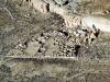
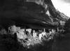
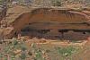
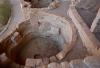
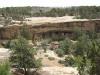
By the tenth century these Ancestral Puebloans had converted the earlier pithouse design into their famous sandstone kivas—the large, one-room ceremonial structures typical of many Puebloan archaeological sites throughout Colorado and the Southwest. Ancestral Puebloans did not transfer these structural designs to the famous cliff sides until about the mid-thirteenth century, when some event—climatic, cultural, or likely both—prompted the hasty construction of houses and kivas in the canyon alcoves.
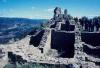
Mesa Verde’s most famous and most photographed structure, the Cliff Palace, was finished sometime between 1260 and 1280, before a twenty-five-year drought decimated the food supply and possibly prompted the mass exodus from the mesa. By 1300 the Ancestral Puebloans had disappeared from the region. Although the drought certainly played a large role in the abandonment, it is still not entirely clear what combination of events in the late thirteenth century forced the Ancestral Puebloans to leave Mesa Verde.
Nuche
The Nuche, or Ute people, were present in the Four Corners region by 1300, and by 1500 southwest Colorado was occupied by a band of Utes called the Weenuche: the “long time ago people.” Although the Weenuche came to be the most dominant group, other groups of Utes—such as the Muache and Capote—as well as Navajo and Southern Paiute people also frequented the Four Corners area.
The Utes lived off the natural resources of Colorado’s mountains and river valleys, hunting elk, deer, jackrabbit, and other game. They also gathered a wide assortment of wild berries and roots, including the versatile yucca root. In the summer they followed game high into the San Juan Mountains, and in the winter they followed the animals back to the shelter of the lower river valleys, such as the Dolores.
Spanish Era
By the early seventeenth century, the northern frontier of New Spain pressed up against the lands of the Weenuche and other Utes in southwestern Colorado. The Nuche relationship with the Spaniards was one of alternate raiding and trading. As early as 1640 they had acquired horses from their European neighbors to the south. Horses allowed the Utes, who were already accustomed to ranging across vast territories, to cover even more ground in search of trade or larger populations of game such as buffalo. The horse also increased the value of river valleys, as Ute ponies could find ample forage there in winter.
Official Spanish exploration of the Montezuma County area began with the expedition of Juan de Rivera in 1765. Rivera’s mission was to have the Utes guide him to the Colorado River—then known as the Río del Tizón—and investigate rumors of silver deposits in the mountains.
In the summer of 1765 Rivera’s expedition reached the Dolores River near present-day Dolores, but Nuche there warned him not to proceed any farther until the fall, when cooler weather prevailed. Rivera’s group headed back to New Mexico. In the fall Rivera again crossed the Montezuma County area on his way to the Dolores River.
Rivera’s expedition carved out a route for future traders and explorers. In July 1776, the Spanish friars Silvestre Escalante and Francisco Domínguez were dispatched to find an overland passage from Santa Fé to Monterey, California. After following Rivera’s old route through present-day Archuleta, La Plata, Montezuma, Dolores, and San Miguel Counties, Dominguez and Escalante pushed northeast into the Gunnison Valley and then northwest into Utah. In October a punishing blizzard forced them back to Santa Fé.
They had not found passage to Monterey, but Domínguez and Escalante had pushed farther into western Colorado than any other Spanish explorer. They were also the first Europeans to document the Mesa Verde region in 1776.
Explorers, Farmers, and Ranchers
The Montezuma County area belonged to Mexico after it won independence from Spain in 1821, but was ceded to the United States after the Mexican-American War (1846–48). In 1859 an American expedition led by Captain John Macomb left Santa Fé and crossed the northern part of present-day Montezuma County. Macomb sought to map a railroad or wagon route through southwest Colorado, but found the terrain too difficult for practical construction of either. His expedition was the last official US military exploration of southwest Colorado.
The years after 1876 saw increased migration of Hispano ranchers and farmers from New Mexico into present-day Montezuma County. Most of these migrants opposed the opening of Ute lands to Americans, as they feared it would increase Anglo dominance of the area. Colorado historian William Wyckoff notes that “many Ute babies had Hispano baptismal godparents, and relations between the two groups were cordial.” The continued presence of Anglo-American, Hispano, and Native Americans led to the development of a rich cultural mosaic that persists to the present.
Ute Mountain Ute Reservation
The US government brokered a treaty with Utes in 1868 that left the Native Americans a huge reservation encompassing nearly the entire western third of Colorado. But against the wishes of both the government and the Utes, prospectors soon filtered into the San Juans northeast of present-day Montezuma County. A few successful strikes in the mountains in the early 1870s led to the Brunot Agreement in 1873.
Under the agreement, the Ute leader Ouray agreed to cede the San Juan Mountains, including the eastern part of present-day Montezuma County, to the United States. The agreement also established the Southern Ute Indian Reservation south of the ceded territory for the Weenuche, Capote, and Muache Utes.
Later, the Dawes Act of 1887 directed that reservation land be allotted to individual tribal members, but many Weenuches rejected the idea of allotment and preferred one large reservation. To that end, in 1895 the government established the Ute Mountain Ute Reservation out of the western edge of the Southern Ute Reservation. Weenuche Utes began settling the reservation in 1897, and they gained federal recognition as the Ute Mountain Ute Tribe in 1915.
Tension between whites and Utes in Montezuma County persisted despite the reservations. One common source of conflict was the tendency of white ranchers’ herds to stray onto the reservation. In addition, the federal government proved unreliable in furnishing supplies promised to the Utes in earlier treaties, so some Utes left the reservation to hunt. White ranchers often accused Utes of killing their cattle and committing other crimes. These tensions sometimes resulted in violence, such as when Utes killed at least a dozen ranchers in the spring of 1881, or when whites murdered a group of Utes at a campsite along Beaver Creek in 1885. That same year Weenuches burned the Genthner home on Totten Lake, near Cortez, and killed the family patriarch, though his wife and six children survived. Sporadic violence continued until the last major conflict in 1915, which left several Utes and members of a joint Anglo-American-Mexican posse dead.
Despite these conflicts, Utes and non-native residents managed to coexist peacefully in Montezuma County after the turn of the century. In the first third of the twentieth century, many Utes found employment as cowboys or farmers. Today, the Ute Mountain Ute Tribe hosts guided tours of their homeland for visitors.
County Establishment
The first permanent white residents in Montezuma County were miners who explored the Mancos Valley on the heels of the Brunot Agreement. In 1873 a small and bankrupt mining party consisting of Almarion Root, Alex K. Fleming, Robert Jones, and Henry Lightner found a deposit that would become the site of the Comstock Mine in the La Plata Mountains. The party was fortunate to run into Captain John Moss, who was scouting Colorado mining ventures for wealthy San Francisco bankers. Moss took some samples from the Root party’s find, which impressed his California sponsor.
Moss returned from San Francisco with his own party in July, finding and naming the Montezuma Valley. By July 1874, Moss had found an agreeable settlement site on the fertile lands of the Mancos Valley, and he decided to set up a town that could support mining operations in the mountains. The town of Mancos was incorporated in 1894. More white settlers arrived in the Mancos community over the next few years, and in 1877 the first settlers arrived in the Dolores River valley.
Montezuma County was carved from the western portion of La Plata County in 1889. A little more than a year later, the Rio Grande & Southern Railroad connected Mancos and Dolores, providing an important boost to the county economy.
In 1886 the town of Cortez was laid out by M. J. Mack, an engineer for the Montezuma Valley Water Supply Company. Construction on the town’s main irrigation ditch, which took water from the Dolores River, continued into 1887; in the meantime, the town’s first residents had to haul in their own barrels of water on wagons. On July 4, 1890, the first flowing water supplied the town’s few residences via a forty-foot flume.
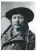
By the late nineteenth century, ranching was the dominant economic activity in Montezuma County; nearly every homesteader had a cattle herd, and there were thousands of cattle ranging across the river valleys. Ranchers had also driven Native Americans off of grassy flattops such as Mesa Verde; in 1888 rancher Richard Wetherill discovered the Cliff Palace while chasing some of his herd.
Montezuma County’s ranching economy faded in the early twentieth century, however, as the amount of irrigated farmland increased and the creation of national parks and forest reserves reduced the amount of available grazing land.
Mining
A handful of mining activities began in the mountains east of Mancos in the late nineteenth century and continued into the twentieth. The Sundown Mine, the area’s first high-paying mine, was established in 1894; in 1898 Montezuma County mines produced an estimated $15,000 worth of gold.
Though it never stopped, mining tapered off at the beginning of the twentieth century, only to experience a revival in the 1930s. In 1933 Charles Starr and his sons, Raymond and Howard, found a rich gold deposit east of Mancos. They opened the Red Arrow Mine, and its first shipment produced about $6,000 worth of gold. The mine was closed during World War II but was reopened after the war and remains in production today.
In mid-February 1936, an avalanche wiped out a mining camp east of Mancos belonging to the Hesperus Mining Company, killing six and destroying company property worth $75,000. The event remains the deadliest avalanche in county history.
Twentieth Century
At the turn of the century, the county’s economy began a transition from ranching to farming. The amount of irrigated land increased from 2,122 acres in 1889 to 27,176 acres in 1909, while the number of farms grew from 261 in 1900 to 1,004 in 1910. Apple and peach orchards sprang up to the north and west of Cortez, in Lebanon and McElmo Canyon. McElmo Canyon peaches even took home awards at the 1904 St. Louis World’s Fair.
Cortez continued to grow in the early twentieth century. In 1908 the Clifton Hotel burned down, and owner Johnny Brown and his wife rebuilt it as the Brown Palace Hotel, which still operates today. By 1910 the town had 565 residents.
Construction of the county’s first major road, a highway that ran from Durango to Mancos, began in 1913 and was complete by 1919. By the 1920s Montezuma County had a population of about 7,000 and boasted more than 40,000 acres of irrigated land. Its agricultural bounty included alfalfa, corn, wheat, pears, cherries, apples, peaches, sheep, and cattle for beef and dairy.
To prevent the exploitation of timber and grass reserves, President Theodore Roosevelt created the San Juan Forest Reserve—along with many other reserves in Colorado—in 1905. The government also created Mesa Verde National Park in 1906, Hovenweep National Monument in 1919, and Yucca House National Monument in 1923, bringing more of the county’s land under federal management. Mesa Verde National Park was expanded in 1911 via a land exchange with the Weenuche so it would include more of the famous cliff dwellings. County farmers largely supported the creation of new federal lands because it preserved their water supply; ranchers, however, viciously opposed these developments because they curtailed the amount of grazing land.
Along with the rest of the country, Montezuma County suffered during the Great Depression (1929–39), as production of nearly every agricultural commodity dropped sharply. After World War II, the county’s farms rebounded, and the economy added the new pillars of tourism and energy extraction. Spurred on by the uptick in automobile ownership, the number of visitors to Mesa Verde National Park more than tripled between 1941 and 1953. Major oil strikes west of Pleasant View in 1948 and in nearby Aneth, Utah, in 1956 turned Cortez into a prominent supply center for the oil industry. Uranium prospecting also funneled money into Cortez during the 1950s.
The local oil and uranium industries spurred significant development in Cortez. The city got a new hospital in 1948. Main Street was paved in 1951, followed by several other streets in 1953–54. Two new elementary schools were added in 1950 and 1955. The first commercial planes arrived in the 1950s, and the first broadcast from the new local radio station, KVFC, hit the airwaves in 1955. With the energy industries fueling development, Cortez’s population grew from 2,680 in 1950 to 6,764 1960, an increase of more than 150 percent.
The energy boom of the 1950s went bust in the 1960s, and Montezuma County became even more dependent on tourism. In 1992, the state designated Montezuma County as one of its Enterprise Zones—economically underdeveloped areas where businesses can receive tax breaks just for setting up shop. This allowed Montezuma County businesses to claim more than $7 million in tax credits and create 1,677 jobs between 1992 and 2013.
In the 1980s, the federal Bureau of Reclamation began building McPhee Reservoir on the Dolores River. When the project was completed in 1995, it irrigated an additional 35,000 acres, 7,500 of which lay on the Ute Mountain reservation. The reservoir also provides Towaoc, Cortez, and Dolores with a long-term water supply.
Today
The federal government established Canyons of the Ancients National Monument in western Montezuma County in 2000, which brought the amount of land under federal management to about one-third of the county’s total. Tourism remains the main driver of the county economy, although the market value of its agricultural products has increased in recent years.