Lariat Trail Scenic Mountain Drive
Full Article
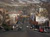
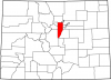
Lariat Trail
Conceived and constructed by William "Cement Bill" Williams, the Lariat Trail climbs roughly five miles and 1,500 feet from Golden to the summit of Lookout Mountain.

Passing Below the M
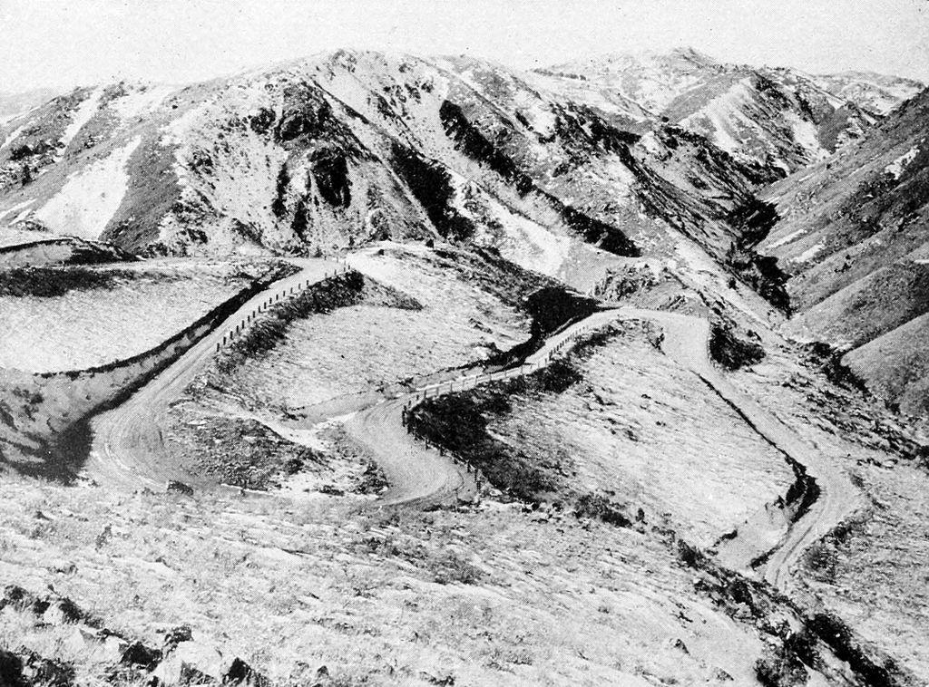
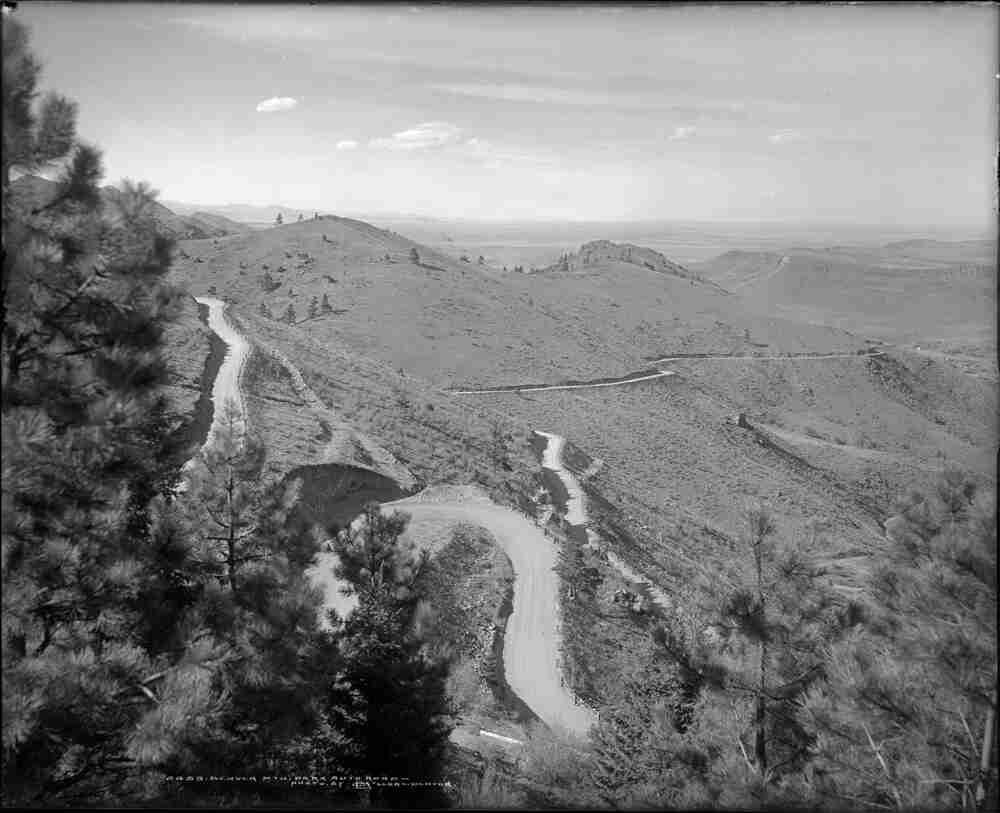
After climbing north toward Clear Creek and making a series of hairpin turns, the Lariat Trail traverses south across Mt. Zion, passing just below the Colorado School of Mines "M."
Spring House
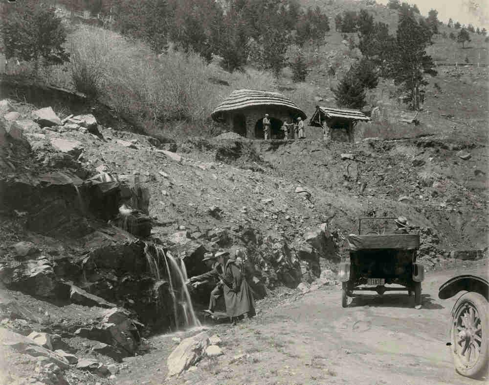
Above Windy Saddle, the road passes Spring House, built in 1916 to provide a rest area for people and cars in need of water.
Lariat Trail
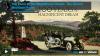
One of the earliest scenic mountain drives in Colorado, the Lariat Trail influenced later scenic roads such as the Pikes Peak Highway.
Driving the Lariat Trail
The Lariat Trail served as the northern entrance to Denver's new system of Mountain Parks and soon became a popular drive, attracting more than 116,000 cars in 1918.
Planned and built by William “Cement Bill” Williams from about 1910 to 1914, the Lariat Trail Scenic Mountain Drive winds roughly five miles and 1,500 feet from Golden to the top of Lookout Mountain. One of the earliest scenic mountain drives in Colorado, the road provided access to the new Denver Mountain Parks system and also influenced later scenic drives such as the Pikes Peak Highway and Trail Ridge Road. In 1990 the road was listed on the National Register of Historic Places, and it is also an integral part of the Lariat Loop National Scenic Byway.
Building the Lariat Trail
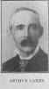
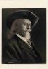
The road up Lookout Mountain grew out of several forces at work in the early 1910s. First, Golden cement contractor William “Cement Bill” Williams wanted to attract more tourists to town, so he planned a road from the city to the summit of Lookout Mountain. Starting in 1910, he used his own money and donations from local businessmen such as Adolph Coors to fund a survey and build a two-foot-wide trail along his proposed route, but the project stalled because of a lack of money.
At roughly the same time, Denver was planning to establish a system of mountain parks west of the city and wanted a network of roads to provide visitors with easy access and scenic views. Initially Denverites eyed a route up Mount Vernon Canyon (now the Interstate 70 corridor), but soon they decided to back Williams’s road up Lookout Mountain as a northern entrance to the parks.
With help from Denver’s business community, in 1913 Williams secured funding for his road: $15,000 from the state and $7,500 each from Denver and Jefferson County. That summer he and his work crew widened his original two-foot trail into a road suitable for automobiles. Some sources indicate that landscape architects Saco DeBoer and Frederick Law Olmsted Jr., who consulted on the overall design of the Denver Mountain Parks system, also provided advice on the road’s route as it was being constructed.
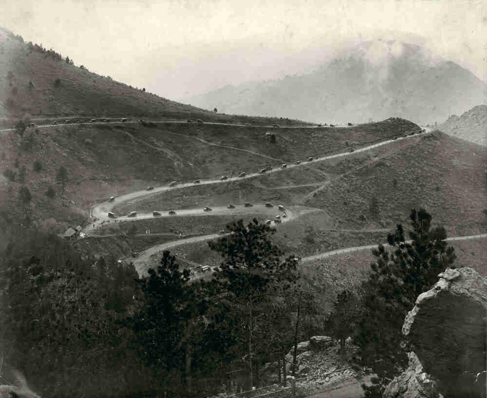
The road managed to scale the steep slopes of Lookout Mountain with no grades over 6 percent. It started by climbing toward the north flank of Mt. Zion above Clear Creek, where it went through three hairpin turns. From there it traversed south across Mt. Zion and just under the Colorado School of Mines “M” (built in 1908) to Windy Saddle. Just past Windy Saddle was the Spring House, a rustic rest area with a natural spring. After four more tight hairpins, the road curled east and wrapped around the summit.
By 1914, Denver had acquired its first two mountain parks—Lookout Mountain and Genesee—and the Lariat Trail up Lookout Mountain had been extended as far as Genesee Saddle to provide access to both. Just one problem remained: Denver still owed Williams $2,500. Williams owned a piece of land that the road crossed, so in May 1914 he set up a gate and prevented drivers registered in Denver from going through. Drivers from elsewhere were free to use the road. In July Denver settled with Williams and secured a northern entry to its growing system of mountain parks.
Lariat Loop
The Lariat Trail became tremendously popular as the rise of automobile tourism and the opening of Denver’s mountain parks led Denverites and other tourists to explore the foothills by car. When William “Buffalo Bill” Cody was buried on Lookout Mountain in 1917, for example, at least 20,000 people used the road to attend the ceremony. That summer nearly 70,000 cars traveled to Denver’s Mountain Parks, many using the Lariat Trail. In 1918 more than 116,000 cars drove the road.
One major reason for the Lariat Trail’s popularity was that it could be connected via Bergen Park to the newly improved Bear Creek Canyon Drive to make the forty-mile Lariat Loop, which provided easy access to many of Denver’s Mountain Parks. The Lariat Trail was considered the north entry to the parks, and Bear Creek Canyon was the south entry. In 1917 large stone pillars marking the “Entrance to the Denver Mountain Parks” were erected at the start of both roads. The pillars at the base of Bear Creek Canyon in Morrison have been removed, but the pillars near the bottom of Lookout Mountain still stand.
Today the Lariat Trail (also known as Lookout Mountain Road) has been paved and widened, but it maintains the same alignment that Williams laid out in the early 1910s. It remains a popular scenic drive and also draws cyclists and runners looking to test themselves on the nearly 1,500-foot climb. At the summit, the Buffalo Bill Museum parking lot includes a memorial to “Cement Bill” at a spot overlooking the road.
In 1990 the Lariat Trail was listed on the National Register of Historic Places. The full Lariat Loop was named a Colorado Scenic Byway in 2002 and a National Scenic Byway in 2009.
10th Grade
The Lariat Trail Scenic Mountain Drive, also known as Lookout Mountain Drive, winds five miles and 1,500 feet from the town of Golden to the top of Lookout Mountain. One of the earliest scenic mountain drives in Colorado, it was planned and built by William “Cement Bill” Williams from about 1910 to 1914. The road provided access to the new Denver Mountain Parks system and influenced later scenic drives such as the Pikes Peak Highway and Trail Ridge Road. In 1990 the road was listed on the National Register of Historic Places, and it is an integral part of the Lariat Loop National Scenic Byway.
Building the Lariat Trail
The road up Lookout Mountain grew out of several forces at work in the early 1910s. Golden cement contractor William “Cement Bill” Williams wanted to attract more tourists to town, so he planned a road from the city of Golden to the summit of Lookout Mountain. In 1910 he used his own money and donations from local businessmen such as Adolph Coors to fund a survey and build a two-foot-wide trail along his proposed route. However, the project stalled because of a lack of money.
At the same time, the City of Denver was planning to establish a system of mountain parks west of the city. They needed a network of roads to provide visitors with easy access and scenic views. Initially, Denver planned to construct a route up Mount Vernon Canyon, which later became the Interstate 70 corridor. But the city decided that Williams’s road up Lookout Mountain would better serve as the northern entrance to the parks.
In 1913, with help from Denver’s business community, Williams secured funding for his road. Funds included $15,000 from the state and $7,500 each from Denver and Jefferson County. That summer he and his work crew widened the original two-foot trail into a road suitable for automobiles. Landscape architects Frederick Law Olmsted, Jr. and Saco DeBoer helped design the Denver Mountain Parks system, and it is likely that they provided advice on the road as it was being built.
The road was designed to scale the steep slopes of Lookout Mountain with no grades over 6 percent. It started by climbing toward the north flank of Mt. Zion above Clear Creek, where it went through three hairpin turns. From there it traversed south across Mt. Zion and just under the Colorado School of Mines “M” to Windy Saddle. Just past Windy Saddle was the Spring House, a rustic rest area with a natural spring. After four more tight hairpins, the road curled east and wrapped around the summit.
By 1914 Denver had acquired its first two mountain parks, Lookout Mountain and Genesee Park. The Lariat Trail Drive on Lookout Mountain had been extended as far as Genesee Saddle to provide access to both. Just one problem remained: Denver still owed Williams $2,500 for the construction of the road. The road crossed a piece of land that Williams owned, so in May 1914 he set up a gate and stopped cars that were registered in Denver from passing through; drivers from elsewhere, meanwhile, were allowed through. In July Denver settled payment with Williams and secured the northern entrance to its growing system of mountain parks.
Lariat Loop
The opening of Denver’s mountain parks allowed tourists to explore Denver’s foothills by car, and the Lariat Trail became tremendously popular with the rise of automobile tourism. When William “Buffalo Bill” Cody was buried on Lookout Mountain in 1917, at least 20,000 people used the road to attend the ceremony. That summer nearly 70,000 cars traveled to Denver’s Mountain Parks, many using the Lariat Trail. In 1918 more than 116,000 cars drove the road.
The major reason for the Lariat Trail’s popularity was that it connected Bergen Park to the newly improved Bear Creek Canyon Drive. This created the forty-mile Lariat Loop that provided easy access to many of Denver’s Mountain Parks. The Lariat Trail was considered the north entry to the parks, while Bear Creek Canyon was considered the south entry. In 1917 large stone pillars marking the “Entrance to the Denver Mountain Parks” were put up at the start of both roads. The pillars at the base of Bear Creek Canyon in Morrison have been removed, but the pillars near the bottom of Lookout Mountain still stand.
Today the Lariat Trail, which is also known as Lookout Mountain Road, has been paved and widened, but it maintains the same alignment that Williams laid out in the early 1910s. It remains a popular scenic drive and also draws cyclists and runners looking to test themselves on the nearly 1,500-foot climb. At the summit, a memorial to “Cement Bill” is located near the Buffalo Bill Museum, at a spot overlooking the road.
In 1990 the Lariat Trail was listed on the National Register of Historic Places. The full Lariat Loop was named a Colorado Scenic Byway in 2002 and a National Scenic Byway in 2009.
8th Grade
The Lariat Trail Scenic Mountain Drive, also known as Lookout Mountain Drive, was one of the earliest scenic mountain drives in Colorado. It winds five miles and 1,500 feet from the city of Golden to the top of Lookout Mountain. It was planned and built by William “Cement Bill” Williams from 1910 to 1914. The road provided access to the new Denver Mountain Parks system. In 1990 the road was listed on the National Register of Historic Places.
Building the Lariat Trail
The road to the top of Lookout Mountain began in the early 1910s. Cement contractor William “Cement Bill” Williams planned the road to attract more tourists to the town of Golden. In 1910 he used his own money and donations from local businessmen, including beer brewer Adolph Coors, to build a two-foot-wide trail along his proposed route. However, the project stalled because of a lack of money.
At the same time, Denver was establishing a system of mountain parks west of the city. It needed roads to provide visitors with easy access and scenic views. Initially, Denver considered a route up Mount Vernon Canyon, which later would become Interstate 70. But the city chose Williams’s road up Lookout Mountain to serve as the northern entrance to the new parks.
In 1913 Williams secured funding for the road, including $15,000 from the state and $7,500 each from Denver and Jefferson County. That summer a work crew widened the original two-foot trail into a road suitable for automobiles.
The road was designed to climb the steep slopes of Lookout Mountain with no grade over 6 percent. It started uphill toward Mt. Zion above Clear Creek, where it went through three hairpin turns. From there it traversed south across Mt. Zion and passed under the Colorado School of Mines “M” to Windy Saddle. Just past Windy Saddle was the Spring House, a rustic rest area with a natural spring. After four more tight hairpins, the road curled east and wrapped around the summit.
By 1914 Denver had acquired its first two mountain parks, Lookout Mountain and Genesee Park. The Lariat Trail Drive on Lookout Mountain was extended to provide access to both parks. Just one problem remained: Denver still owed Williams $2,500 for construction of the road. Williams owned a piece of land that the road crossed, and in May 1914, he set up a gate and stopped cars that were registered in Denver from travelling on the road. Drivers from elsewhere were free to use the road. In July Denver settled payment with Williams and secured the northern entrance to its growing system of mountain parks.
Lariat Loop
The Lariat Trail became popular with the rise of automobile tourism. Starting in the 1910s, the automobile was changing the way that Americans traveled. The road allowed tourists to explore the Denver’s foothills by car. In 1917 nearly 70,000 cars traveled to Denver’s Mountain Parks. In 1918 more than 116,000 cars drove the road. William “Buffalo Bill” Cody was buried on Lookout Mountain in 1917, and at least 20,000 people drove up the road to attend the ceremony.
The Lariat Trail was connected to the newly improved Bear Creek Canyon Drive. This created the forty-mile Lariat Loop. These roads combined to provide easy access to many of Denver’s Mountain Parks. In 1917 large stone pillars marking the “Entrance to the Denver Mountain Parks” were erected at the start of both roads. The pillars at the base of Bear Creek Canyon in Morrison have been removed, but the pillars near the bottom of Lookout Mountain still stand.
Today
Today the Lariat Trail has been paved and widened. It follows the same route that Williams laid out in the early 1910s. It is a popular scenic drive that also draws cyclists and runners looking to test themselves on the 1,500-foot climb. At the summit is a memorial to “Cement Bill” at the Buffalo Bill Museum.
In 1990 the Lariat Trail was listed on the National Register of Historic Places. The full Lariat Loop was named a Colorado Scenic Byway in 2002 and a National Scenic Byway in 2009.
4th Grade
The Lariat Trail Scenic Mountain Drive is a road that runs from the town of Golden to the top of Lookout Mountain. It is also known as Lookout Mountain Drive. It is a beautiful road that winds through Denver’s foothills. It was one of the earliest scenic mountain drives in Colorado.
Building the Lariat Trail
The road up Lookout Mountain started in the early 1910s. William Williams wanted to attract more tourists to Golden. He was a cement contractor whose nickname was “Cement Bill.” He planned a road from town to the summit of Lookout Mountain. In 1910 he built a two-foot wide trail where he wanted to build the road. He used his own money and donations from local businessmen. Adolph Coors, who started the beer company, was one of the funders. But Williams ran out of money before he could build the road.
At the same time, the City of Denver was creating mountain parks west of the city. They needed new roads to give visitors a way to get to these parks. They decided that Williams’s road up Lookout Mountain was a good place for a road to the parks.
In 1913 Denver helped Williams get the money for the road. He got $15,000 from the State of Colorado. Denver and Jefferson County each paid $7,500. That summer the two-foot trail was widened. It was made into a road for automobiles. Frederick Olmsted Jr. and Saco DeBoer were landscape architects who helped design the Denver Mountain Parks system. They helped decide where the road would go.
The road went up Lookout Mountain, which is very steep. It started up Mt. Zion, where it went through three hairpin turns. From there it went south across Mt. Zion. It passed under the Colorado School of Mines “M.” Just past Windy Saddle was the Spring House, a rest area with a natural spring. After four more tight hairpins, the road curved and wrapped around the summit.
By 1914 Denver had its first two mountain parks. They were Lookout Mountain and Genesee Park. The Lariat Trail Drive was extended to Genesee to connect the parks.
Just one problem remained. Denver owed Williams $2,500 for the construction of the road. Williams owned a piece of land that the road crossed. In May 1914 he set up a gate and stopped cars from Denver from travelling on the road. Drivers from other places, however, were free to use the road. In July Denver paid Williams the money he was owed. Then, the northern entrance to Denver’s mountain parks was open to everyone.
Lariat Loop
Starting around 1915, automobiles changed the way that Americans travelled. The new road let people explore the foothills by car. In 1917 nearly 70,000 cars drove through the parks. In 1918 more than 116,000 cars drove the road. The Lariat Trail allowed people from Denver to see the new parks in one day.
The Lariat Trail was connected to another road called Bear Creek Canyon Drive. The two roads together made a forty-mile loop that passed through the beautiful Colorado mountains. The Lariat Trail was the north entrance to the parks. Bear Creek Canyon was the south entrance. In 1917 large stone pillars marking the “Entrance to the Denver Mountain Parks” were put up at both ends of the road. The pillars at the base of Bear Creek Canyon in Morrison have been removed. But the pillars near the bottom of Lookout Mountain still stand.
Today the Lariat Trail has been paved and widened. It is on the same route that Williams laid out in the early 1910s. It is still a popular scenic drive. Cyclists and runners also use the road. At the summit, there is a memorial to “Cement Bill” on a spot overlooking the road.
In 1990 the Lariat Trail was listed on the National Register of Historic Places. The full Lariat Loop was named a Colorado Scenic Byway in 2002. It became a National Scenic Byway in 2009.