Boulder Flood of 1894
Full Article
The 1894 Boulder flood was a natural disaster that reshaped the landscape of Boulder County, wiping out some communities and forcing others to come together to rebuild. Like other extreme weather events, the 1894 deluge played an integral role in the development of the affected communities. Some, particularly mining camps in the high canyons, were lost immediately, while others eventually failed after years of futile struggle. Still others, including Boulder and its surrounding communities, made slow, difficult recoveries.
Beginning
On May 30, 1894—Memorial Day—in Boulder, a rainstorm persisted throughout the day and continued into the night, saturating the ground and choking streams already swollen with runoff following the winter’s heavy snowfall. At around 10 pm, some residents noticed that Boulder Creek was quickly rising, and with the rain still coming down, the flood threat became serious. That night, in the canyon above town, Boulder Creek rose out of its banks, carrying huge boulders in the current as the flood gained momentum. The water tore through the canyon, laying waste to mines, railroad bridges, and settlements along the way. By daybreak, it had begun pouring out of the narrows and onto the flats, debris crashing down with earth-trembling force.
Boulder Hit
Early that morning, Harvey Poole and a friend stood on the Sixth Street Bridge as Boulder Creek surged rapidly under their feet. There was a sudden loud crash and a tearing sound, and both men leaped to the north bank of the creek as the bridge broke in half behind them. The current pulled the twisted wreckage about 100 feet downstream, where it lodged against the bank. A short time later, a man named J. B. Andrews had a similar narrow escape on the Twelfth Street Bridge. He had gone out to post a sign warning teamsters not to cross the structure, but before he could put up the sign the bridge disintegrated underneath him. A desperate jump to the riverbank kept the water from enveloping him as well.
High school student Harriet Roosa came upon the shattered Sixth Street Bridge while walking her usual route to class that morning. Stranded, she walked back and forth on the north bank of the stream as crowds of people gathered around, looking on in disbelief. Boulder Creek, normally thirty feet wide, had widened to an angry river several hundred feet across. The rubble-strewn waters battered the city all morning, tearing down telegraph and telephone poles, crashing into creekside buildings, and laying waste to railroad tracks.
The current forced its way through the headgate of Beasley Ditch—a small irrigation channel for local farmers—and obliterated its banks, tearing apart the farmland and homes adjacent to the ditch. The effect was devastating in Poverty Flats, a subdivision housing many of Boulder’s poorer families. Bordered on the north and south by Water and Arapahoe streets and on the west by Seventeenth Street, this low-lying area had accumulated almost six feet of standing water by the end of the day.
Around noon, a crowd gathered at Water and Twelfth (today’s Canyon and Broadway) to watch the water hammer away at the foundation of Jacob Faus’s house. A well-known blacksmith, Faus lived on the banks of a sharp bend in Boulder Creek (the present-day site of Civic Park), and the water roared into the crook of the curve and ate away at the banks. After several hours, the earth gave in, and Faus’s house floated off its foundation. It lodged against the bank 200 yards downstream and was smashed to kindling by the force of the current.
In the midst of the destruction, some residents took heroic steps to rescue the stranded and save lives. Boulder police officer Ed Knapp came to the aid of Madame Kingsley, one of Boulder’s more disreputable citizens, by wading to her island bordello near Tenth and Water Streets and carrying out her—and her two pugs—on his shoulders. Knapp later tried to persuade Marinus G. “Marine” Smith to leave his house near Water and Sixteenth. Smith, a prominent Boulder pioneer, refused to leave his home that lay half underwater. Holing up on his second floor, Smith ranted that his enemies would take his home if he were to leave it. Later, he ended up in the State Insane Asylum in Pueblo.
In Poverty Flats and other areas threatened with total submersion, twenty men with teams and wagons ferried people to higher ground. As the water continued to rise and the roads became muddy slicks, they set the wagons aside and carried out passengers on horseback. Some owners hauled off heavy furniture before the floodwaters could claim it, while many others moved goods out of threatened storerooms. As the flood raged, Boulder’s top two photographers—rivals Lawrence Bass and “Rocky Mountain” Joe Sturtevant—scrambled to document the catastrophe as best they could. Sturtevant lived south of Boulder Creek in Gregory Canyon, and with all of the bridges out, he had no way to reach his studio on the north side of Boulder Creek. Sturtevant eventually crossed the creek and helped to record the disaster and its aftermath.
By day’s end, the flood had washed the city right off the map, taking every road, railroad, and bridge with it. “All telegraph and telephone communication was cut off,” The Denver Republican would later report, “and there was no egress in any direction.” Boulder had become an island, hopelessly cut off from all neighbors and completely alone.
The Day After
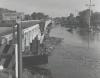
The morning of June 1 brought sunny skies, making the flood’s toll painfully clear. The Sixth, Ninth, Twelfth, and Seventeenth Street bridges over Boulder Creek were completely gone. Although the Fourth Street Bridge still stood, parts of it had twisted into a sagging semicircle, impassable by foot or team. The loss of these spans cut Boulder in half, with the north and south sides isolated from each other. The passenger train depot stood under more than three feet of water, with one narrow-gauge engine still parked in the building’s new moat. The Union Pacific, Denver & Gulf Railway line that connected the city to Denver suffered grievous damages, not only in town but also on the prairies east of Boulder. Surprisingly, for all its ferocity, the flood did not kill a single resident of Boulder.
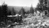
The floodwaters had fanned out as they moved downstream, forming a lake nearly a mile wide between Boulder and Valmont—right on top of many farmers’ plots. The flood deposited a thick layer of sand, rocks, and branches that completely covered the fertile soil east of town. Beasley Ditch was a total loss; the many farmers who relied on it for irrigation wondered if their crops would survive. The damage in the nearby mountains far exceeded that in Boulder or the farming regions. Some reports claimed that the water had come down the canyons in a wall ten or twelve feet high. Jamestown was virtually destroyed and the hamlets of Crisman, Glendale, and Springdale sustained severe damage. Many of the houses and stores in Crisman were entirely gone, and the town’s narrow-gauge railroad—its lifeline—had disappeared downriver. Many of Glendale’s buildings were swept away and three residents were killed when the main road washed out. Very little remained of Springdale, known for its mineral springs. Its main tourist attraction—the Seltzer House Hotel—tumbled away in the raging floodwaters. Niwot resident Frank Bader reported that part of Springdale’s bowling alley washed up in his town, located on the prairie several miles northeast of Boulder.
With roads and bridges out throughout the county, deliveries of food, water, and medicine could not get through. Offers of assistance came as early as 5 p.m. on the day of the flood, but moving any supplies to the south side of town required a bridge of some kind. Edwin J. Temple, a Boulder alderman, solved that problem by rigging up a rope and pulley system between some cottonwood trees near Sixth Street. Using this precarious conveyance, people and supplies could shuttle back and forth across the still-raging Boulder Creek. James H. Baker and a team of residents raised a second rope bridge at Twelfth Street. Though somewhat flimsy, these homemade connections at least put the stranded southsiders back into contact with the rest of the town and provided a short-term solution to the supply problem.
Upon further inspection of the damages to Boulder and its infrastructure, a daunting picture emerged. The flood had taken Boulder County’s railroads, mines, and farms—three pillars of the regional economy—out of commission. Thousands of workers in those industries stood idle, and their jobs were in jeopardy. Most of the small farming towns around Boulder needed supplies, and the mountain towns were completely cut off and desperate for help. In Longmont, the Electric Light Company ran out of coal and had to borrow from private bins; six days later, still waiting on a coal shipment, it prepared to shut down.
Recovery
On June 2, two days after the flood, the Union Pacific, Denver & Gulf attempted to restore service between Denver and Boulder. Repairing the extensive track damage would take weeks, but as a stopgap the railroad sent a train around the flood and into Boulder by way of Brighton, Greeley, and Fort Collins. This circuitous route put every possible connection to the test, but the train still had to turn back, to everyone’s great disappointment. In addition to their labor, the people of Boulder donated money to help out in the crisis. Fundraising efforts managed to pull in nearly $2,000 in less than a day. Still, the city of Boulder was unable to hire a contractor to rebuild the Twelfth Street Bridge until July 20. The firm would not finish its work until November 8—nearly two months overdue—and the new Ninth Street Bridge was not ready for traffic until January 3, 1895, nearly seven months after the flood.
As Boulder got back on its feet, the nearby mountain towns continued to struggle. Some of the mines eventually reopened and resumed production, but most of the stamp mills operating in support of those mines had been destroyed entirely. The flood had occurred immediately after the Silver Panic of 1893, which devastated the state’s silver industry and proved to be another disastrous event for the mining towns. Approximately 60 percent of Boulder County’s ore production was in gold, but those camps struggled nonetheless. To make matters worse, the Union Pacific Railroad announced that it would not rebuild its narrow-gauge Greeley, Salt Lake & Pacific Railroad line up Boulder and Four Mile Canyons. The railroad had little choice, as the flood destroyed all but two miles of the track and nearly sixty bridges had washed away.
The consequences of the flood were felt for a long time, and some communities, including Balarat, Springdale, and Jamestown, were either wiped out completely or never made a full recovery. The loss of rail and road connections also put the Four Mile Canyon mining camps of Sunset, Copper Rock, Wall Street, and Crisman on the path to failure. Boulder eventually made a full recovery. Its citizens found ways to solve the town’s problems together and to do so with determination, resourcefulness, and a little bit of humor. A Daily Camera editor remarked that “one thing is worthy of note, however, as it shows the spirit of our people. I have not seen a gruesome face or heard an oath or any expression showing a spirit of dejection. In the midst of ruin, we laugh and joke while repairing the waste.”
Adapted from Mona Lambrecht, “‘Good Baptist Weather’: Boulder County and the Flood of 1894,” Colorado Heritage Magazine 20, no. 4 (2001).